Toggle navigation
LMEC Home
Exhibitions
Georeferencing
Tools for Teachers
Collections
My Favorites
Sign Up / Log In
Search
Search the map portal
Map Collection
Map Collection
Map Sets
Search
Search
Search for
Search In
All Fields
Creator
Title
Subject
Place
Search All Digital Collections
Advanced Search
13680 Results
Filter your Search
Place
North and Central America
10,344
United States
8,475
Massachusetts
2,789
Suffolk (county)
1,677
Boston
1,633
Europe
1,415
Canada
950
New York
649
more
Place
»
Topic
Boston (Mass.)--Maps
747
City planning--Massachusetts--Boston--Maps
418
United States--History--Revolution, 1775-1783--Maps
329
United States--Maps
322
Real property--Massachusetts--Boston--Maps
254
Urban renewal--Massachusetts--Boston--Maps
254
Massachusetts--Maps
231
Insurance surveys
197
more
Topic
»
Date
Date range begin
–
Date range end
Current results range from
1482
to
2023
View distribution
Creator
United States. Hydrographic Office
597
Boston Redevelopment Authority
404
Des Barres, Joseph F. W. (Joseph Frederick Wallet), 1722-1824
247
Royal United Services Institute for Defence and Security Studies
160
Jefferys, Thomas, -1771
154
George, III, King of Great Britain, 1738-1820
152
George, IV, King of Great Britain, 1762-1830
151
O.H. Bailey & Co
148
more
Creator
»
Format
Maps/Atlases
13,499
Manuscripts
985
Prints
102
Books
49
Drawings/Illustrations
44
Photographs
15
Objects/Artifacts
13
Documents
7
more
Format
»
Georeferenced
Yes
979
No
12,701
Collection
Norman B. Leventhal Map & Education Center Collection
9,096
American Revolutionary War-Era Maps
3,305
Boston and New England Maps
2,915
Urban Maps
2,471
Maritime Charts and Atlases
1,169
William L. Clements Library Collection
910
Library of Congress Collection
618
Boston Redevelopment Authority Collection
475
more
Collection
»
Available to use
No known restrictions
10,246
Creative Commons license
1,678
Search Constraints
Sort by relevance
relevance
title
date (asc)
date (desc)
Number of results to display per page
20 per page
10
per page
20
per page
50
per page
100
per page
View results as:
grid view
map view
Search Results
2741.
Coste occidentale d'Afrique, depuis le Détroit de Gibraltar jusqu' au XIe dégré de latitude septentrionale : tirée de la...
2742.
Les costes aux environs de la Riviere de Misisipi : decouvertes par Mr. de la Salle en 1683 et reconnues par Mr. le Chevallier...
2743.
Costes et rivieres de Virginie, de Mariland, et de Nouvelle Angletere
2744.
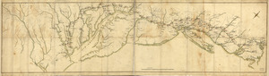
Côte de York-town à Boston: Marches de l'armée
2745.
Cottage City, Martha's Vineyard, Mass
2746.
The cotton kingdom
2747.
Cotwool Manufacturing Company "Cowan Mill," Lewiston, Me. [insurance map]
2748.
The counti of Warwick the shire towne and citie of Coventre described
2749.
The counties of Southern California
2750.
The countries of the Caribbean : including Mexico, Central America, the West Indies and the Panama Canal
2751.
The country around Herat : projected from Major Holditch's map
2752.
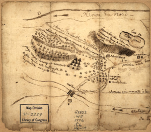
Country between North River and Croton River
2753.
The country of So red the rose, by Stark Young, Scribners
2754.
The country round Washington : the Chesapeake and the Potomac
2755.
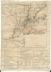
The Country twenty five miles round New York
2756.
The country twenty five miles round New York
2757.
County atlas of Berkshire Massachusetts
2758.
County atlas of Hampshire, Massachusetts
2759.
County atlas of Hampshire, Massachusetts : from actual surveys
2760.
County atlas of Middlesex, Massachusetts : from actual surveys
‹ Prev
Next ›
1
2
…
134
135
136
137
138
139
140
141
142
…
683
684


![Cotwool Manufacturing Company "Cowan Mill," Lewiston, Me. [insurance map]](https://bpldcassets.blob.core.windows.net/derivatives/images/commonwealth:4j03df27t/image_thumbnail_300.jpg)