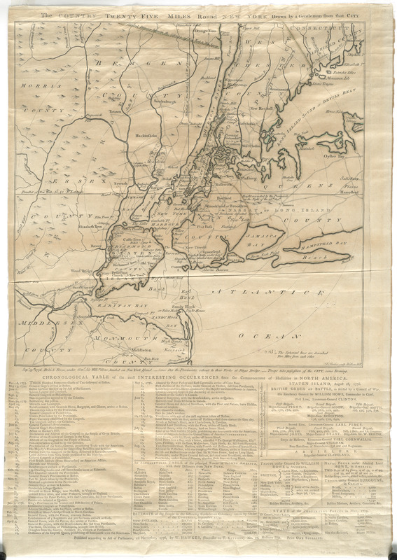
The country twenty five miles round New York
This map is also available in American Revolutionary Geographies Online (ARGO), a collections portal especially built for material relating to the American Revolutionary War Era. Visit ARGO to learn more about this item and explore the historical geography of North America in the late eighteenth century.
Item Information
- Title:
- The country twenty five miles round New York
- Engraver:
- Barber, J.
- Publisher:
- Hawkes, W.
- Name on Item:
-
drawn by a gentleman from that city ; J. Barber, sculp.
- Date:
-
1776
- Format:
-
Maps/Atlases
- Location:
- George Washington's Mount Vernon
- Collection (local):
-
Richard H. Brown Revolutionary War Map Collection at Mount Vernon
- Subjects:
-
New York Region--History--Revolution, 1775-1783--Maps--Early works to 1800
- Places:
-
New York
- Extent:
- 1 map ; hand col. ; 37 x 38 cm., on sheet 60 x 42 cm.
- Terms of Use:
-
No known copyright restrictions.
This work is licensed for use under a Creative Commons Attribution Non-Commercial Share Alike License (CC BY-NC-SA).

- Publisher:
-
London :
W. Hawkes
- Scale:
-
Scale [ca. 1:215,000]
- Language:
-
English
- Catalog Record:
-
MVLA record
- Notes:
-
Relief shown pictorially.
"Published according to act of Parliament, 1st November, 1776, by W. Hawkes, (successor to T. Kitchin) ..."
Shows radial distances.
Includes "Chronological table of the most interesting occurrences since the commencement of hostilities in North America."
First state of this map.
- Identifier:
-
06_01_008142

![[A map of part of Pennsylvania & Maryland intended to shew, at one view, the several places proposed for opening a communication between the waters of the Delaware & Chesopeak Bays]](https://bpldcassets.blob.core.windows.net/derivatives/images/commonwealth:z603vt12v/image_thumbnail_300.jpg)


