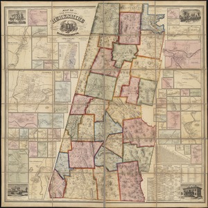
County atlas of Berkshire Massachusetts

Item Information
- Title:
- County atlas of Berkshire Massachusetts
- Cartographer:
- Beers, F. W. (Frederick W.)
- Publisher:
- J.B. Beers & Co.
- Name on Item:
-
from actual surveys by and under the direction of F.W. Beers ; engraved and printed by J.B. Beers & Co.
- Date:
-
1876
- Format:
-
Maps/Atlases
- Location:
-
Boston Public Library
Norman B. Leventhal Map & Education Center - Collection (local):
-
Norman B. Leventhal Map & Education Center Collection
- Subjects:
-
Berkshire County (Mass.)--Maps
Berkshire County (Mass.)--Directories
Berkshire County (Mass.)--Pictorial works
Real property--Massachusetts--Berkshire County--Maps
Landowners--Massachusetts--Berkshire County--Maps
Buildings--Massachusetts--Berkshire County--Pictorial works
- Places:
-
MassachusettsBerkshire (county)
- Extent:
- 1 atlas (116 p.) : ill., col. maps. (some folded) ; 41 cm.
- Terms of Use:
-
No known copyright restrictions.
No known restrictions on use.
- Publisher:
-
New York :
R.T. White & Co.
- Language:
-
English
- Notes:
-
Hand-colored cadastral maps.
Includes table of distances, population tables, business notices (p. 111-116) and lithographic illustrations of commercial and residential buildings.
- Identifier:
-
06_01_018511
- Call #:
-
G1233.B4 B44 1876
- Barcode:
-
39999059010221

![[Map of Berkshire County]](https://bpldcassets.blob.core.windows.net/derivatives/images/commonwealth:wd376641h/image_thumbnail_300.jpg)
