Toggle navigation
LMEC Home
Exhibitions
Georeferencing
Tools for Teachers
Collections
My Favorites
Sign Up / Log In
Search
Search the map portal
Map Collection
Map Collection
Map Sets
Search
Search
Search for
Search In
All Fields
Creator
Title
Subject
Place
Search All Digital Collections
Advanced Search
132 Results
My Search
Start Over
1864
Remove constraint 1864
Filter your Search
Place
North and Central America
115
United States
83
Virginia
14
Suffolk (county)
9
Boston
8
Georgia
7
Massachusetts
7
Richmond
7
more
Place
»
Topic
United States--History--Civil War, 1861-1865--Maps
15
Virginia--History--Civil War, 1861-1865--Maps
10
Richmond (Va.)--History--Civil War, 1861-1865--Maps
7
Nautical charts--Superior, Lake
6
Boston (Mass.)--Maps
5
Massachusetts--Maps
5
United States--Maps
5
Alabama--Maps
4
more
Topic
»
Date
Date range begin
–
Date range end
Current results range from
1758
to
1932
View distribution
Creator
Smith, Leonard S. (Leonard Sewall), 1864-1947
8
Wisconsin Geological and Natural History Survey
8
U.S. Lake Survey
7
Graham, J. D. (James Duncan), 1799-1865
6
Michler, N. (Nathaniel), 1827-1881
6
Raynolds, W. F. (William Franklin), 1820-1894
6
Strasser, J.
6
Theilkuhl, F.
6
more
Creator
»
Format
Maps/Atlases
130
Manuscripts
3
Prints
2
Georeferenced
Yes
18
No
114
Collection
Norman B. Leventhal Map Center Collection
122
Boston and New England Maps
16
Urban Maps
14
Maritime Charts and Atlases
13
David Judkins Weaver Papers
6
Ralph Finos Map Collection at Phillips Academy
3
Massachusetts Real Estate Atlases
2
Sidney R. Knafel Map Collection at Phillips Academy
2
more
Collection
»
Available to use
No known restrictions
125
Creative Commons license
1
Search Constraints
Sort by date (desc)
relevance
title
date (asc)
date (desc)
Number of results to display per page
20 per page
10
per page
20
per page
50
per page
100
per page
View results as:
grid view
map view
Search Results
1.
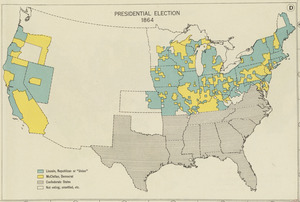
Presidential election 1864
2.
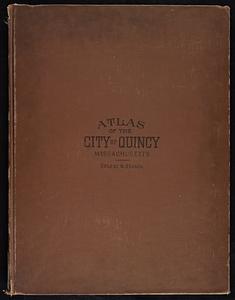
Atlas of the city of Quincy, Norfolk County, Massachusetts : compiled from the latest plans and original surveys
3.
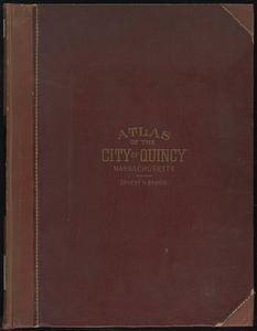
Atlas of the city of Quincy, Norfolk County, Massachusetts
4.
Atlas of the city of Quincy, Norfolk County, Massachusetts
5.
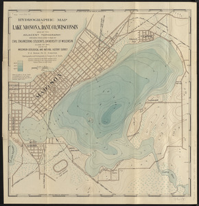
Hydrographic map of Lake Monona, Dane Co., Wisconsin and of the adjacent topography
6.
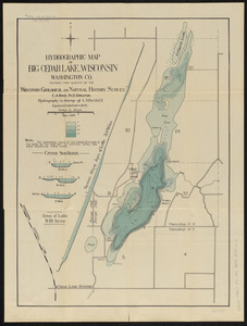
Hydrographic map of Big Cedar Lake, Wisconsin, Washington Co.
7.
Hydrographic map of Delavan and Lauderdale Lakes Walworth Co. Wisconsin
8.
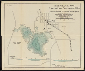
Hydrographic map of Elkhart Lake, Sheboygan Co. Wis.
9.
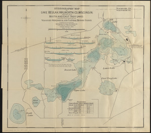
Hydrographic map of Lake Beulah, Walworth Co., Wisconsin, together with Booth and East Troy Lakes
10.
Hydrographic map of Lake Geneva, Wisconsin
11.
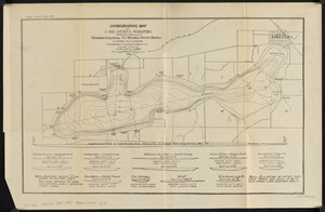
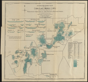
Hydrographic map of the Chain-O'-Lakes, Waupaca Co. Wis.
12.
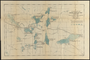
Hydrographic map of the Oconomowoc-Waukesha Lake District, Waukesha Co. Wis.
13.
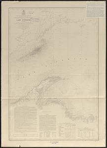
Lake Superior : chart no. 1
14.
Lake Superior : chart no. 3
15.
Lake Superior : chart no. 2
16.
North end of Lake Michigan including Green Bay and the straits of Mackinac
17.
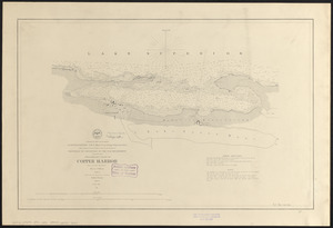
Preliminary chart of Copper Harbor
18.
Northern Pacific Rail Road and connections
19.
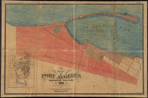
Map of Port Angeles, Washington Territory : compiled from a true copy of the U.S. survey thereof on file in the General Land...
20.
Arctic Sea, Spitzbergen : from the Swedish survey of 1861 to 1864, corrected from the German & Norwegian explorations to 1872
‹ Prev
Next ›
1
2
3
4
5
6
7