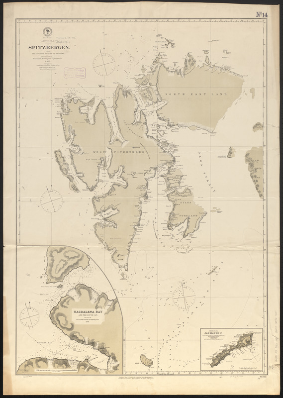
Arctic Sea, Spitzbergen : from the Swedish survey of 1861 to 1864, corrected from the German & Norwegian explorations to 1872
Item Information
- Title:
- Arctic Sea, Spitzbergen : from the Swedish survey of 1861 to 1864, corrected from the German & Norwegian explorations to 1872
- Title (alt.):
-
Spitzbergen
- Issuing body:
- United States. Hydrographic Office
- Date:
-
1882
- Format:
-
Maps/Atlases
- Location:
-
Boston Public Library
Norman B. Leventhal Map & Education Center - Collection (local):
-
Norman B. Leventhal Map & Education Center Collection
- Subjects:
-
Nautical charts--Norway--Svalbard--Maps
Nautical charts--Norway--Spitsbergen Island--Maps
Svalbard (Norway)--Maps
Spitsbergen Island (Norway)--Maps
- Places:
-
Svalbard (territory)Spitsbergen (island)Spitsbergen (area)
- Extent:
- 1 map : color ; 90 x 63 cm
- Terms of Use:
-
No known copyright restrictions.
No known restrictions on use.
- Publisher:
-
Washington, D.C. :
Hydrographic Office
- Edition:
- Cor. (82.XII.81)
- Scale:
-
Scale approximately 1:1,000,000
- Language:
-
English
- Notes:
-
Relief shown by hachures and spot heights. Depths shown by soundings.
Insets: Magdalena Bay and the South Gat -- Greenland Sea, Jan Mayen Id.
- Identifier:
-
06_01_015519
- Call #:
-
G9096.P5 svar .U55
- Barcode:
-
39999085937637


