Toggle navigation
LMEC Home
Exhibitions
Georeferencing
Tools for Teachers
Collections
My Favorites
Sign Up / Log In
Search
Search the map portal
Map Collection
Map Collection
Map Sets
Search
Search
Search for
Search In
All Fields
Creator
Title
Subject
Place
Search All Digital Collections
Advanced Search
1084 Results
My Search
Start Over
Back Bay Boston
Remove constraint Back Bay Boston
Filter your Search
Place
North and Central America
833
United States
531
Massachusetts
238
Suffolk (county)
179
Boston
173
Canada
115
South America
62
Asia
61
more
Place
»
Topic
Boston (Mass.)--Maps
60
City planning--Massachusetts--Boston--Maps
48
Back Bay (Boston, Mass.)--Maps
47
North America--Maps--Early works to 1800
35
Landowners--Massachusetts--Boston--Maps
26
Real property--Massachusetts--Boston--Maps
26
New England--Maps--Early works to 1800
24
Nova Scotia--Maps--Early works to 1800
24
more
Topic
»
Date
Date range begin
–
Date range end
Current results range from
1565
to
2020
View distribution
Creator
United States. Hydrographic Office
277
Des Barres, Joseph F. W. (Joseph Frederick Wallet), 1722-1824
64
Boston Redevelopment Authority
36
Jefferys, Thomas, -1771
24
Sayer, Robert, 1725-1794
24
Franke, M. (Max)
23
U.S. Lake Survey
22
United States Exploring Expedition (1838-1842)
21
more
Creator
»
Format
Maps/Atlases
1,069
Manuscripts
69
Drawings/Illustrations
10
Objects/Artifacts
3
Prints
3
Books
1
Posters
1
Georeferenced
Yes
54
No
1,030
Collection
Norman B. Leventhal Map & Education Center Collection
945
Maritime Charts and Atlases
481
Boston and New England Maps
265
American Revolutionary War-Era Maps
231
Urban Maps
138
Boston Redevelopment Authority Collection
54
Mapping Boston Collection
40
Library of Congress Collection
35
more
Collection
»
Available to use
No known restrictions
946
Creative Commons license
112
Search Constraints
Sort by relevance
relevance
title
date (asc)
date (desc)
Number of results to display per page
20 per page
10
per page
20
per page
50
per page
100
per page
View results as:
grid view
map view
Search Results
141.
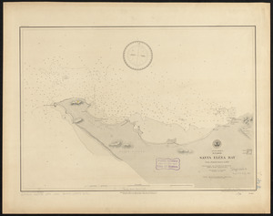
South America, Ecuador, Santa Eléna Bay : from a British survey in 1847
142.
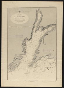
North America, Newfoundland, La Poile Bay : from the latest British surveys
143.
Vineyard Sound and Buzzards Bay, Massachusetts
144.
Fangaloa Bay, north side of Upolu
145.
St. Lawrence Bay showing Lutke's Harbor
146.
Gulf of Mexico, Bay of Campeche : from British surveys in 1852, corrected to 1872
147.
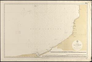
Map of Bohemia, Pensacola Bay, Florida
148.
West Indies, Santo Domingo, Samaná Bay : surveyed by the officers of the U.S.S. Despatch, Commander W.R. Bridgman U.S.N....
149.
S.w. coast of Africa, Table Bay : from British surveys, corrected to 1872
150.
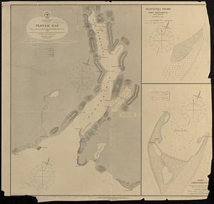
Pacific Ocean, Behrings Sea, Plover Bay : from a survey by Lieut. Maximov Imp! Russian Navy, 1876
151.
St. Lawrence Bay showing Lutke's Harbor
152.
Massachusetts Bays Program community resource atlas
153.
North America, east coast of Newfoundland, Cape Bonavista to Bay Bulls including Trinity, & Conception Bays : from Brit....
154.
Proposed park system from the Common to the West Roxbury Park including the Back Bay and Muddy river improvements, Jamaica Pond...
155.
Copy of a plan of South Bay
156.
Massachusetts Bay Transportation Authority system route map
157.
Massachusetts Bay Transportation Authority system route map
158.
Motor routes that intersect the Bay Circuit
159.
West-Indies, n. coast of Haiti, from Monte Christi to Fort Dauphin Bay ; Fort Dauphin Bay : from a French Survey
160.
A Chart of the north part of America, describing the sea coast of Groenland, Dawies Streights, Baffins Bay, Hudsons Streights,...
‹ Prev
Next ›
1
2
…
4
5
6
7
8
9
10
11
12
…
54
55