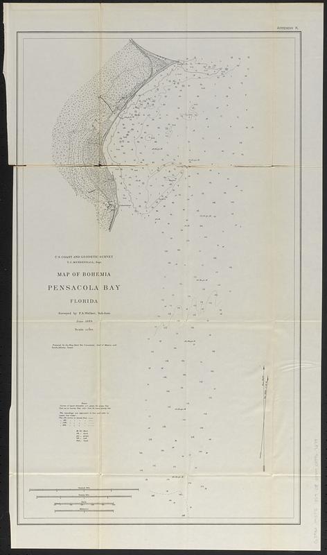
Map of Bohemia, Pensacola Bay, Florida
Item Information
- Title:
- Map of Bohemia, Pensacola Bay, Florida
- Issuing body:
- United States. Commission on Navy-Yards
- Contributor:
- Mendelhall, T. C.
- Surveyor:
- Welker, P. A.
- Issuing body:
- United States. Navy Department
- Cartographer:
- U.S. Coast and Geodetic Survey
- Name on Item:
-
surveyed by P.A. Welker, Sub-Asst. ; June 1889 ; U.S. Coast and Geodetic Survey, T.C. Mendelhall, Supt. ; prepared for the Navy Yard Site Commission, Gulf of Mexico and South Atlantic Coasts
- Date:
-
[ca. 1900]
- Format:
-
Maps/Atlases
- Genre:
-
Bathymetric maps
- Location:
-
Boston Public Library
Norman B. Leventhal Map & Education Center - Collection (local):
-
Norman B. Leventhal Map & Education Center Collection
- Subjects:
-
Pensacola Bay (Fla.)--Maps
Navigation--Florida--Pensacola Bay
Coasts--Florida--Maps
- Places:
-
FloridaPensacola Bay
- Extent:
- 1 map ; 67 x 38 cm
- Terms of Use:
-
No known copyright restrictions.
No known restrictions on use.
- Publisher:
-
[Washington] :
[Government Printing Office]
- Scale:
-
Scale 1:12,000
- Language:
-
English
- Notes:
-
Relief shown by form lines. Depths shown by bathymetric soundings and isolines. "The soundings are expressed in feet and refer to mean low water."
Shows magnetic variation for the year 1889.
"Appendix K."
Detached from a report from the Navy Department issued approximately 1900.
- Identifier:
-
06_01_018421
- Call #:
-
G3932.P45P5 1889 .U5
- Barcode:
-
39999085967279