Toggle navigation
LMEC Home
Exhibitions
Georeferencing
Tools for Teachers
Collections
My Favorites
Sign Up / Log In
Search
Search the map portal
Map Collection
Map Collection
Map Sets
Search
Search
Search for
Search In
All Fields
Creator
Title
Subject
Place
Search All Digital Collections
Advanced Search
2261 Results
My Search
Start Over
london
Remove constraint london
Filter your Search
Place
North and Central America
1,479
United States
921
Europe
363
Canada
347
North America
194
New York
128
Massachusetts
111
New England
104
more
Place
»
Topic
North America--Maps--Early works to 1800
137
Coasts--Nova Scotia--Maps
64
New England--Maps--Early works to 1800
57
United States--History--French and Indian War, 1754-1763--Maps
57
United States--History--French and Indian War, 1754-1763--Maps, Manuscript--Early works to 1800
56
United States--Maps--Early works to 1800
54
United States--History--Revolution, 1775-1783--Maps
40
Nova Scotia--Maps--Early works to 1800
39
more
Topic
»
Date
Date range begin
–
Date range end
Current results range from
1624
to
1999
View distribution
Creator
Des Barres, Joseph F. W. (Joseph Frederick Wallet), 1722-1824
242
Jefferys, Thomas, -1771
167
George, III, King of Great Britain, 1738-1820
149
George, IV, King of Great Britain, 1762-1830
148
Sayer, Robert, 1725-1794
115
Faden, William, 1749-1836
109
Moll, Herman, d. 1732
72
Robert Sayer and John Bennett (Firm)
57
more
Creator
»
Format
Maps/Atlases
2,219
Manuscripts
161
Prints
23
Drawings/Illustrations
15
Books
4
Objects/Artifacts
1
Georeferenced
Yes
137
No
2,124
Collection
American Revolutionary War-Era Maps
1,355
Norman B. Leventhal Map & Education Center Collection
1,305
Maritime Charts and Atlases
263
British Library Collection
163
William L. Clements Library Collection
160
Boston and New England Maps
152
Richard H. Brown Revolutionary War Map Collection at Mount Vernon
146
MacLean Collection Map Library
140
more
Collection
»
Available to use
No known restrictions
1,271
Creative Commons license
569
Search Constraints
Sort by relevance
relevance
title
date (asc)
date (desc)
Number of results to display per page
20 per page
10
per page
20
per page
50
per page
100
per page
View results as:
grid view
map view
Search Results
1321.
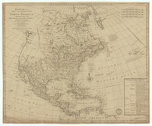
Bowles's new one-sheet map of America, divided into it's provinces, colonies, states, &c.
1322.
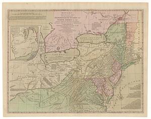
Bowles's new one-sheet map of the independent states of Virginia, Maryland, Delaware, Pensylvania, New Jersey, New York,...
1323.
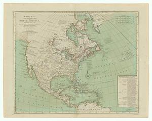
Bowles's new pocket map of North America divided into it's provinces, colonies, &c.
1324.
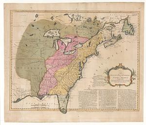
Bowles's new pocket map of the following independent states of North America, viz. Virginia, Maryland, Delaware, Pensylvania,...
1325.
Bradshaw's map of Europe shewing the railways opened and in progress
1326.
Bradshaw's map of the railways, in Central Europe
1327.
Bradshaw's map of the Rhine from Rotterdam to Schafhausen
1328.
Bradshaw's new map of the railways in Great Britain for 1872
1329.
Bradshaw's plan of Paris, and map of the environs
1330.
The British & French dominions in North America particularly shewing the French encroachments through all the British...
1331.
British America, comprehending Canada, Labrador, New-Foundland, Nova Scotia &c
1332.
The British and Russian frontiers in Central Asia
1333.
British camp at Trudruffrin from the 18th. to the 21st. of September 1777 : with the attack made by Major General Grey against...
1334.
The British colonies in North America
1335.
British colonies in North America : drawn from the best authorities
1336.
British dominions in America agreeable to the treaty of 1763 : divided into the several provinces, and jurisdictions
1337.
British possessions in North America
1338.
Canada
1339.
Cannonade at Pass Krug, 3d. October 1758
1340.
Canso Harbor
‹ Prev
Next ›
1
2
…
63
64
65
66
67
68
69
70
71
…
113
114