Toggle navigation
LMEC Home
Exhibitions
Georeferencing
Tools for Teachers
Collections
My Favorites
Sign Up / Log In
Search
Search the map portal
Map Collection
Map Collection
Map Sets
Search
Search
Search for
Search In
All Fields
Creator
Title
Subject
Place
Search All Digital Collections
Advanced Search
13385 Results
Filter your Search
Place
North and Central America
9,353
United States
7,078
Suffolk (county)
1,664
Boston
1,621
Europe
1,035
Canada
949
Massachusetts
794
New York
532
more
Place
»
Topic
Boston (Mass.)--Maps
741
City planning--Massachusetts--Boston--Maps
418
United States--History--Revolution, 1775-1783--Maps
329
United States--Maps
315
Urban renewal--Massachusetts--Boston--Maps
254
Real property--Massachusetts--Boston--Maps
252
Massachusetts--Maps
219
Insurance surveys
197
more
Topic
»
Date
Date range begin
–
Date range end
Current results range from
1482
to
2023
View distribution
Creator
United States. Hydrographic Office
595
Boston Redevelopment Authority
403
Des Barres, Joseph F. W. (Joseph Frederick Wallet), 1722-1824
247
Royal United Services Institute for Defence and Security Studies
160
Jefferys, Thomas, -1771
154
George, III, King of Great Britain, 1738-1820
152
George, IV, King of Great Britain, 1762-1830
151
O.H. Bailey & Co
148
more
Creator
»
Format
Maps/Atlases
13,205
Manuscripts
985
Prints
102
Books
49
Drawings/Illustrations
44
Photographs
15
Objects/Artifacts
13
Documents
7
more
Format
»
Georeferenced
Yes
979
No
12,406
Collection
Norman B. Leventhal Map Center Collection
8,891
American Revolutionary War-Era Maps
3,305
Boston and New England Maps
2,804
Urban Maps
2,397
Maritime Charts and Atlases
1,150
William L. Clements Library Collection
910
Library of Congress Collection
618
Boston Redevelopment Authority Collection
475
more
Collection
»
Available to use
No known restrictions
9,952
Creative Commons license
1,677
Search Constraints
Sort by relevance
relevance
title
date (asc)
date (desc)
Number of results to display per page
20 per page
10
per page
20
per page
50
per page
100
per page
View results as:
grid view
map view
Search Results
11121.
Road map of the Boston district showing the metropolitan park system.
11122.
Road map of the Boston District, showing the metropolitan park system
11123.
Road map of the Boston district showing the metropolitan park system
11124.
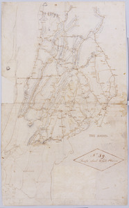
Road map of the island of Rhode Island, or Aquidneck
11125.
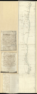
Road map of Worcester County, Mass
11126.
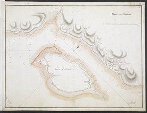
ROAD OF COUDRE
11127.
Roads about White Plains : no 59
11128.
Roads and communications of Sinkiang
11129.
Roads and country that Col. Campbell marched thro'--Ebenezer to Augusta in Georgia
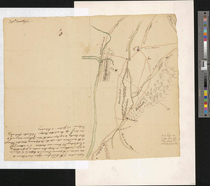
11130.
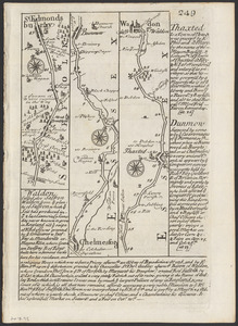
The roads from Chelmsford to St. Edmunds Bury
11131.
Roads from Windsor to Easton through the highlands
11132.
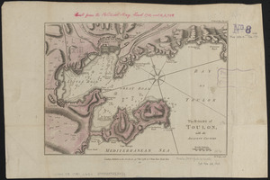
The Roads of Toulon, with the adjacent country
11133.
The roads of ye south part of Great Britain, called England and Wales : Containing all ye cities, market towns, post towns,...
11134.
Robinson's atlas of Norfolk County, Massachusetts : compiled from official records, private plans & actual surveys
11135.
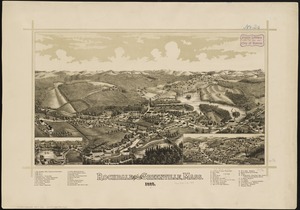
Rochdale and Greenville, Mass : 1887
11136.
Rochester, N.H : Gonic and East-Rochester, 1884
11137.
Rock Island-Frisco lines and Chicago & Eastern Illinois R.R : traverse the richest and most prosperous commonwealths in the Union
11138.
Rockland
11139.
Rock's illustrated map of London
11140.
Rohmer Medford Wool Scouring Company, Medford, Mass. [insurance map]
‹ Prev
Next ›
1
2
…
553
554
555
556
557
558
559
560
561
…
669
670


![Rohmer Medford Wool Scouring Company, Medford, Mass. [insurance map]](https://bpldcassets.blob.core.windows.net/derivatives/images/commonwealth:ww72bz14j/image_thumbnail_300.jpg)