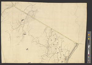
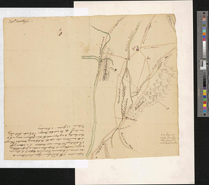
Roads from Windsor to Easton through the highlands
This map is also available in American Revolutionary Geographies Online (ARGO), a collections portal especially built for material relating to the American Revolutionary War Era. Visit ARGO to learn more about this item and explore the historical geography of North America in the late eighteenth century.
Item Information
- Title:
- Roads from Windsor to Easton through the highlands
- Creator:
- Montrésor, John, 1736-1799
- Date:
-
[1770–1779]
- Format:
-
Maps/Atlases
- Genre:
-
Manuscript maps
- Location:
- William L. Clements Library
- Collection (local):
-
William L. Clements Library Collection
- Subjects:
-
Orange County (N.Y.)--Maps
Sussex County (N.J.)--Maps
- Places:
-
New YorkOrange (county)
New JerseySussex (county)
- Extent:
- 1 ms. map : col. ; 32 x 40 cm
- Terms of Use:
-
The University of Michigan Library provides access to these materials for educational and research purposes. These materials may be under copyright. If you decide to use any of these materials, you are responsible for making your own legal assessment and securing any necessary permission. If you have questions about the collection, please contact the William L. Clements Library.
Contact host institution for more information.
- Scale:
-
Scale ca. 1:316,800.
- Language:
-
English
- Catalog Record:
-
Catalog record
- Notes:
-
Title from verso.
Colored pen and ink sketch showing roads between the Hudson and Delaware Rivers in the modern counties of Orange, New York and Sussex, New Jersey.
Numbered locations on the map described in "explanations."
Signed at upper left: Captn. Montresor.
Clinton Maps 204.
- Notes (date):
-
This date is inferred.
- Identifier:
-
1820
- Barcode:
-
B1938510