Toggle navigation
LMEC Home
Exhibitions
Georeferencing
Tools for Teachers
Collections
My Favorites
Sign Up / Log In
Search
Search the map portal
Map Collection
Map Collection
Map Sets
Search
Search
Search for
Search In
All Fields
Creator
Title
Subject
Place
Search All Digital Collections
Advanced Search
2843 Results
My Search
Start Over
atlas
Remove constraint atlas
Filter your Search
Place
North and Central America
1,647
United States
987
Europe
464
Massachusetts
348
Canada
271
Asia
190
South America
189
Suffolk (county)
163
more
Place
»
Topic
Landowners--Massachusetts--Boston--Maps
115
Real property--Massachusetts--Boston--Maps
106
United States--Maps
87
Boston (Mass.)--Maps
63
United States--History--French and Indian War, 1754-1763--Maps
63
Saint Lawrence River--Maps
41
Nautical charts--Early works to 1800
39
North America--Maps--Early works to 1800
36
more
Topic
»
Date
Date range begin
–
Date range end
Current results range from
1482
to
2023
View distribution
Creator
United States. Hydrographic Office
582
Des Barres, Joseph F. W. (Joseph Frederick Wallet), 1722-1824
118
Ptolemy, 2nd cent
100
Bromley, George Washington
99
Bromley, Walter Scott
97
G.W. Bromley & Co.
75
Carey, Mathew, 1760-1839
74
Paullin, Charles Oscar, 1868 or 1869-1944
70
more
Creator
»
Format
Maps/Atlases
2,827
Manuscripts
58
Books
37
Prints
8
Documents
5
Drawings/Illustrations
1
Georeferenced
Yes
142
No
2,701
Collection
Norman B. Leventhal Map & Education Center Collection
2,386
Maritime Charts and Atlases
1,150
American Revolutionary War-Era Maps
504
Boston and New England Maps
374
Urban Maps
250
Massachusetts Real Estate Atlases
144
William L. Clements Library Collection
92
Mapping Boston Collection
61
more
Collection
»
Available to use
No known restrictions
2,292
Creative Commons license
158
Search Constraints
Sort by relevance
relevance
title
date (asc)
date (desc)
Number of results to display per page
20 per page
10
per page
20
per page
50
per page
100
per page
View results as:
grid view
map view
Search Results
1061.
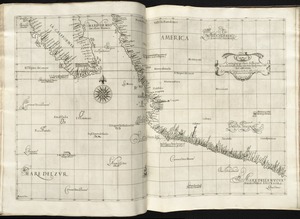
Carta particolare della parte ocidentale della nuova Spagnia, è del la California
1062.
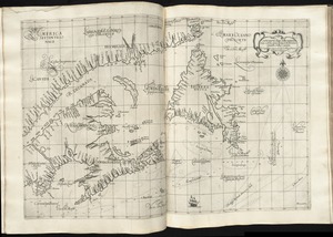
Carta particolare della terra nuoua con la Gran Baia et il Fiume Grande della Canida
1063.
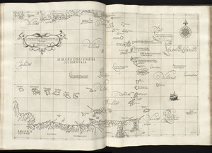
Carta particolare dell'India Ocidentale, con la terra ferma dal' capo di Paria sin al' capo S. Romano
1064.
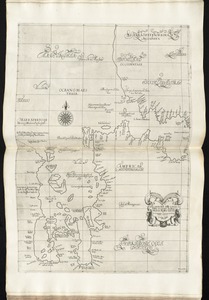
Carta particolare dell'Isola Ispaniola è S. Gioni. nel'India ocidentle. con l'Isola Intorno
1065.
Carta particolare dello istreto e mare iscoperto de Hen. Hudson Ingilese nel. 1611
1066.
Carta particolare dello stretto di Iezo fra l'America è l'isola Iezo
1067.
Carta particolare dello Stretto di Magellano è di Maire
1068.
Carte des Isles du Cap Verd : levée en 1819 1820 et 1822
1069.
Carte des isles du Cap-Verd : dressée sur les remarques et les observations les plus exactes des navigateurs
1070.
Carte réduite des costes occidentale d'Afrique : seconde feuille, depuis le Cap Bojador jusqu' a la Riviere de Sierra Leona,...
1071.
Carte reduite des costes occidentales d'Afrique : seconde feuille depuis le Cap Bojador jusqu'a la Riviere de Sierra Léona
1072.
Cattalina Harbor
1073.
Central America, British Honduras, Belize Harbor : from a British Survey in 1829 & 30
1074.
Central America, north coast of Panama, Port Chagres : from a British survey in 1829 & 1840, and a survey in 1875 by the...
1075.
Central America, southern shore of the Caribbean Sea, Chiriqui Lagoon
1076.
Central America, west coast of Costa Rica, Ballena Bay (Gulf of Nicoya) : from a survey in 1885 by the officers of the U.S.S....
1077.
Central America, west coast of Costa Rica, El Rincon Harbor (Gulf of Dulce) : from a survey in 1885 by the officers of the...
1078.
Central America, west coast of Costa Rica, Gulf of Dulce
1079.
Central America, west coast of Costa Rica, Gulf of Nicoya
1080.
Central America, west coast of Costa Rica, Juanilla Bay : from a survey in 1885 by the officers of the U.S.S. Ranger, Commander...
‹ Prev
Next ›
1
2
…
50
51
52
53
54
55
56
57
58
…
142
143