Toggle navigation
LMEC Home
Exhibitions
Georeferencing
Tools for Teachers
Collections
My Favorites
Sign Up / Log In
Search
Search the map portal
Map Collection
Map Collection
Map Sets
Search
Search
Search for
Search In
All Fields
Creator
Title
Subject
Place
Search All Digital Collections
Advanced Search
1080 Results
My Search
Start Over
Back Bay Boston
Remove constraint Back Bay Boston
Filter your Search
Place
North and Central America
830
United States
529
Massachusetts
236
Suffolk (county)
178
Boston
172
Canada
115
South America
62
Asia
61
more
Place
»
Topic
Boston (Mass.)--Maps
60
City planning--Massachusetts--Boston--Maps
48
Back Bay (Boston, Mass.)--Maps
47
North America--Maps--Early works to 1800
34
Landowners--Massachusetts--Boston--Maps
26
Real property--Massachusetts--Boston--Maps
26
New England--Maps--Early works to 1800
24
Nova Scotia--Maps--Early works to 1800
24
more
Topic
»
Date
Date range begin
–
Date range end
Current results range from
1565
to
2020
View distribution
Creator
United States. Hydrographic Office
277
Des Barres, Joseph F. W. (Joseph Frederick Wallet), 1722-1824
64
Boston Redevelopment Authority
36
Jefferys, Thomas, -1771
24
Sayer, Robert, 1725-1794
24
Franke, M. (Max)
23
U.S. Lake Survey
22
United States Exploring Expedition (1838-1842)
21
more
Creator
»
Format
Maps/Atlases
1,066
Manuscripts
69
Drawings/Illustrations
10
Objects/Artifacts
3
Prints
3
Books
1
Georeferenced
Yes
54
No
1,026
Collection
Norman B. Leventhal Map & Education Center Collection
942
Maritime Charts and Atlases
481
Boston and New England Maps
264
American Revolutionary War-Era Maps
230
Urban Maps
138
Boston Redevelopment Authority Collection
54
Mapping Boston Collection
39
Library of Congress Collection
35
more
Collection
»
Available to use
No known restrictions
943
Creative Commons license
112
Search Constraints
Sort by relevance
relevance
title
date (asc)
date (desc)
Number of results to display per page
20 per page
10
per page
20
per page
50
per page
100
per page
View results as:
grid view
map view
Search Results
861.
Indian Ocean : ports on the western coast of Madagascar : from British surveys, corrected to 1874
862.
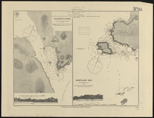
[Manuscript map of coast from Maine to Delaware]
863.
Pas kaart van de zuyd kust van Cuba en van geheel Yamaica en and're bygeleegen plaatsen
864.
The coast of New England
865.
South America--west coast, Patagonia, Concepcion Channel
866.
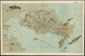
Plan of Sorrento, Maine
867.
La Nuoua Francia
868.
Mediterranean Sea, harbors on the south coast of Sardinia : from a British survey in 1865 ; republished from British Admiralty...
869.
The coast of New England
870.
Arabian Sea, Maskat to Karáchi
871.
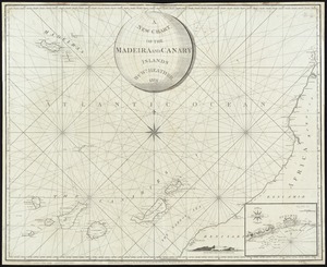
A New Chart of the Madeira and Canary Islands
872.
Tactical pilotage chart, TPC
873.
North Atlantic--Azores, San Miguel : from a British survey in 1844
874.
Fort William & Mary on Piscataqua River in the Province of New Hampshire on the Continent of America
875.
Water resources of the Concord River watershed
876.
Water resources of the lower south coastal watershed
877.
Water resources of the Merrimack River watershed
878.
Water resources of the Neponset River watershed
879.
Townsend's Patent folding globe
880.
Water resources of the Nashua River watershed
‹ Prev
Next ›
1
2
…
40
41
42
43
44
45
46
47
48
…
53
54

![[Manuscript map of coast from Maine to Delaware]](https://bpldcassets.blob.core.windows.net/derivatives/images/commonwealth:x633f976h/image_thumbnail_300.jpg)