Toggle navigation
LMEC Home
Exhibitions
Georeferencing
Tools for Teachers
Collections
My Favorites
Sign Up / Log In
Search
Search the map portal
Map Collection
Map Collection
Map Sets
Search
Search
Search for
Search In
All Fields
Creator
Title
Subject
Place
Search All Digital Collections
Advanced Search
13680 Results
My Search
Start Over
Date facet yearly ssim
1842
Remove constraint Date facet yearly ssim: <span class='single'>1842</span>
Filter your Search
Place
North and Central America
10,344
United States
8,475
Massachusetts
2,789
Suffolk (county)
1,677
Boston
1,633
Europe
1,415
Canada
950
New York
649
more
Place
»
Topic
Boston (Mass.)--Maps
747
City planning--Massachusetts--Boston--Maps
418
United States--History--Revolution, 1775-1783--Maps
329
United States--Maps
322
Real property--Massachusetts--Boston--Maps
254
Urban renewal--Massachusetts--Boston--Maps
254
Massachusetts--Maps
231
Insurance surveys
197
more
Topic
»
Date
Date range begin
–
Date range end
Current results range from
1482
to
2023
View distribution
Creator
United States. Hydrographic Office
597
Boston Redevelopment Authority
404
Des Barres, Joseph F. W. (Joseph Frederick Wallet), 1722-1824
247
Royal United Services Institute for Defence and Security Studies
160
Jefferys, Thomas, -1771
154
George, III, King of Great Britain, 1738-1820
152
George, IV, King of Great Britain, 1762-1830
151
O.H. Bailey & Co
148
more
Creator
»
Format
Maps/Atlases
13,499
Manuscripts
985
Prints
102
Books
49
Drawings/Illustrations
44
Photographs
15
Objects/Artifacts
13
Documents
7
more
Format
»
Georeferenced
Yes
979
No
12,701
Collection
Norman B. Leventhal Map & Education Center Collection
9,096
American Revolutionary War-Era Maps
3,305
Boston and New England Maps
2,915
Urban Maps
2,471
Maritime Charts and Atlases
1,169
William L. Clements Library Collection
910
Library of Congress Collection
618
Boston Redevelopment Authority Collection
475
more
Collection
»
Available to use
No known restrictions
10,246
Creative Commons license
1,678
Search Constraints
Sort by relevance
relevance
title
date (asc)
date (desc)
Number of results to display per page
20 per page
10
per page
20
per page
50
per page
100
per page
View results as:
grid view
map view
Search Results
8661.
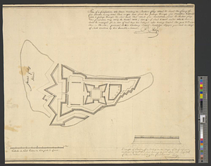
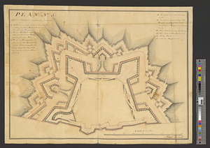
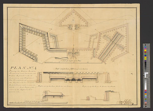
Plan (no. 3) of the citadel compleatly finished
8662.
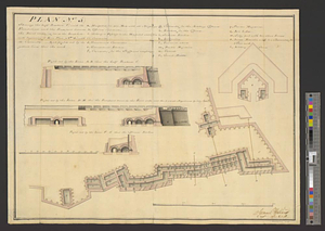
Plan no. 4 shewing the bastion A with its foundations and casemates and bastion B finish'd with its ambrazures and platforms C...
8663.
Plan (no. 5) shewing the half bastion C with its foundations and the rampart towards the river side, as far as the loop-hole...
8664.
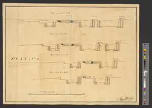
Plan no. 6 shewing the profils cut thro' the different works by the yellow lines seen on plan no. 3
8665.
Plan no II of land of George D. Welles situated in ward 16 Boston
8666.
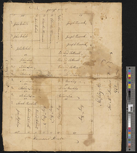
A Plan oe [i.e. of] the British lines on Boston Neck in August 1775
8667.
A plan of 8 lots of city land known as the Arsenal Lot : and 7 lots fronting on Providence St. to be sold at auction, on...
8668.
Plan of 82 building lots, in the town of Brighton, comprising 48 acres of the Parkman Farm next the estate of Saml. Bigelow...
8669.
Plan of a city block in Wilmington, Delaware : for Mr Fredrick Wirt 1772
8670.
Plan of a fortification who seems necessary on Shutters Folly Island to second the firing of Fort Johnson on any vessel that...
8671.
A plan of a new road in the parish of Dechambault
8672.
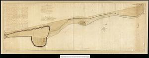
Plan of a part of Beverly in the Colony of the Massachusetts Bay
8673.
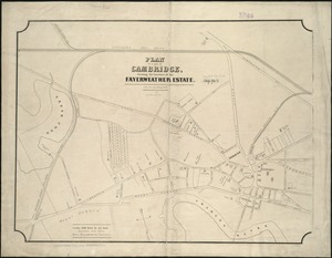
Plan of a part of Cambridge showing the location of the Fayerweather Estate
8674.
Plan of a part of New Brighton, Staten Island, showing the 500 blocks comprised in a proposed sale of lots
8675.
Plan of a portion of the properties of the Long Wharf or Boston Pier & Central Wharf & Wet Dock Corporatins, showing sixteen...
8676.
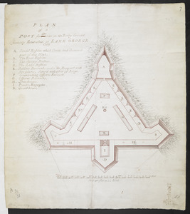
PLAN of a POST for 430 men on the Rocky Ground formerly Retrenched at LAKE GEORGE 1759
8677.
A plan of a rout from Fort Pownall on the river Penobscot in New England to Quebec and from Quebec to Fort Pownall : taken by...
8678.
Plan of a rout undertaken in winter, Jany. 26th : from Quebec, the capital of Canada, to the frontier settlements of the...
8679.
Plan of a settlement call'd Dunlaps Station
8680.
A plan of a survey made to explore the country for a road between Connecticut River & St. Francis
‹ Prev
Next ›
1
2
…
430
431
432
433
434
435
436
437
438
…
683
684

![A Plan oe [i.e. of] the British lines on Boston Neck in August 1775](https://bpldcassets.blob.core.windows.net/derivatives/images/commonwealth:z603vj41n/image_thumbnail_300.jpg)