Toggle navigation
LMEC Home
Exhibitions
Georeferencing
Tools for Teachers
Collections
My Favorites
Sign Up / Log In
Search
Search the map portal
Map Collection
Map Collection
Map Sets
Search
Search
Search for
Search In
All Fields
Creator
Title
Subject
Place
Search All Digital Collections
Advanced Search
91 Results
My Search
Start Over
1803
Remove constraint 1803
Filter your Search
Place
North and Central America
70
United States
61
North America
12
Europe
10
New York
7
Massachusetts
5
Canada
4
Ohio
4
more
Place
»
Topic
North America--Maps--Early works to 1800
8
United States--Maps
7
United States--Maps--Early works to 1800
5
Georgia--Maps
3
Manhattan (New York, N.Y.)--Maps
3
Maryland--Maps
3
New York (N.Y.)--Administrative and political divisions--Maps
3
North America--Maps
3
more
Topic
»
Date
Date range begin
–
Date range end
Current results range from
1753
to
1932
View distribution
Creator
Barker, W. (William), active 1795-1803
32
Carey, Mathew, 1760-1839
32
Burr, David H., 1803-1875
8
Brion de la Tour, Louis, 1743-1803
6
Esnauts et Rapilly
5
Lewis, Samuel, 1753 or 4-1822
5
Arrowsmith, Aaron, 1750-1823
3
Dorman, Moses, 1803-1877
3
more
Creator
»
Format
Maps/Atlases
91
Georeferenced
Yes
8
No
83
Collection
Norman B. Leventhal Map & Education Center Collection
59
American Revolutionary War-Era Maps
31
MacLean Collection Map Library
15
Boston and New England Maps
10
Urban Maps
9
New York Public Library Collection
5
American Antiquarian Society Collection
3
Richard H. Brown Revolutionary War Map Collection at Mount Vernon
3
more
Collection
»
Available to use
No known restrictions
62
Creative Commons license
9
Search Constraints
Sort by relevance
relevance
title
date (asc)
date (desc)
Number of results to display per page
20 per page
10
per page
20
per page
50
per page
100
per page
View results as:
grid view
map view
Search Results
61.
Ohio and N.W. Territory
62.
Pennsylvania
63.
Rhode Island
64.
Tennassee : lately the S. Wn. Territory
65.
The United States of America
66.
Virginia
67.
Map of Oregon and upper California, from the surveys of John Charles Frémont and other authorities
68.
The state of South Carolina: from the best authorities
69.
Amerique Septentrionale divisée en ses principales parties, ou sont distingués les vns des autres les estats suivant qu'il...
70.
Plat of the seven ranges of townships being part of the territory of the United States n.w. of the Ohio River which by a late...
71.
A map of part of the N:W: Territory of the United States : compiled from actual surveys, and the best information
72.
The province of Maine, from the best authorities
73.
The state of Maryland, from the best authorities
74.
The state of New Jersey, compiled from the most authentic information
75.
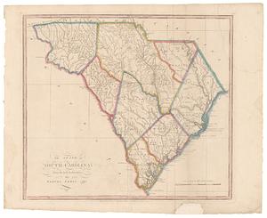
The state of South Carolina : from the best authorities
76.
Chart of Narraganset Bay : surveyed in 1832
77.
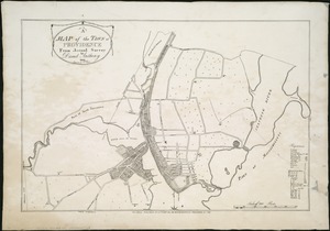
A map of the town of Providence from actual survey
78.
A plan of Boston, from actual survey
79.
Plan of the city of New York
80.
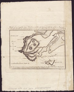
Plan for a complete new harbour, at Howth-town, for the use of his Majesty's mail packet-boats, fishing vessels & in case of a...
‹ Prev
Next ›
1
2
3
4
5