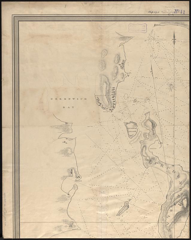
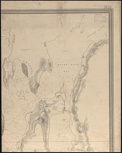
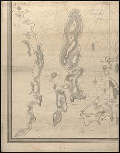
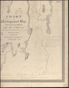
Chart of Narraganset Bay : surveyed in 1832

Item Information
- Title:
- Chart of Narraganset Bay : surveyed in 1832
- Title (alt.):
-
Chart of Narragansett Bay
- Surveyor:
- Wadsworth, A. S.
- Surveyor:
- Gedney, Thomas R., -1857
- Surveyor:
- Wilkes, Charles, 1798-1877
- Surveyor:
- Blake, George S. (George Smith), 1803-1871
- Contributor:
- Woodbury, Levi, 1789-1851
- Engraver:
- Stone, William James, 1798-1865
- Publisher:
- United States. Navy
- Name on Item:
-
by Capt. Alex. S. Wadsworth, Lieut. Thos. R. Gedney, Charles Wilkes Jr., & Geo. S. Blake of the U.S. Navy by order of the Honr. Levi Woodbury, Secretary of the Navy ; W.J. Stone, sc., Washn. City
- Date:
-
[1832]
- Format:
-
Maps/Atlases
- Genre:
-
Nautical charts
- Location:
-
Boston Public Library
Norman B. Leventhal Map & Education Center - Collection (local):
-
Norman B. Leventhal Map & Education Center Collection
- Subjects:
-
Narragansett Bay (R.I.)--Maps
Nautical charts--Rhode Island--Narragansett Bay
- Places:
-
Rhode IslandBristol (county)Narragansett Bay
- Extent:
- 1 map on 4 sheets ; 135 x 106 cm, on sheets 74 x 59 cm
- Terms of Use:
-
No known copyright restrictions.
No known restrictions on use.
- Publisher:
-
[Washington, D.C.?] :
[U.S. Navy?]
- Scale:
-
Scale 1:24,000
- Language:
-
English
- Notes:
-
Relief shown by hachures. Depths shown by soundings and isolines.
- Notes (date):
-
This date is inferred.
- Identifier:
-
06_01_017053A
06_01_017053B
06_01_017053C
06_01_017053D
- Call #:
-
G3772.N37P5 1832 .W33
- Barcode:
-
39999085953782


