Toggle navigation
LMEC Home
Exhibitions
Georeferencing
Tools for Teachers
Collections
My Favorites
Sign Up / Log In
Search
Search the map portal
Map Collection
Map Collection
Map Sets
Search
Search
Search for
Search In
All Fields
Creator
Title
Subject
Place
Search All Digital Collections
Advanced Search
14164 Results
Filter your Search
Place
North and Central America
10,811
United States
8,818
Massachusetts
2,820
Suffolk (county)
1,688
Boston
1,644
Europe
1,428
Canada
1,010
New York
683
more
Place
»
Topic
Boston (Mass.)--Maps
753
City planning--Massachusetts--Boston--Maps
419
United States--History--Revolution, 1775-1783--Maps
331
United States--Maps
331
Real property--Massachusetts--Boston--Maps
254
Urban renewal--Massachusetts--Boston--Maps
254
North America--Maps--Early works to 1800
241
Massachusetts--Maps
236
more
Topic
»
Date
Date range begin
–
Date range end
Current results range from
1482
to
2023
View distribution
Creator
United States. Hydrographic Office
597
Boston Redevelopment Authority
404
Des Barres, Joseph F. W. (Joseph Frederick Wallet), 1722-1824
247
Jefferys, Thomas, -1771
172
United States. National Ocean Service
170
Royal United Services Institute for Defence and Security Studies
160
George, III, King of Great Britain, 1738-1820
152
George, IV, King of Great Britain, 1762-1830
151
more
Creator
»
Format
Maps/Atlases
13,978
Manuscripts
985
Prints
102
Books
53
Drawings/Illustrations
44
Photographs
15
Objects/Artifacts
13
Documents
7
more
Format
»
Georeferenced
Yes
979
No
13,185
Collection
Norman B. Leventhal Map & Education Center Collection
9,162
American Revolutionary War-Era Maps
3,629
Boston and New England Maps
2,936
Urban Maps
2,511
Maritime Charts and Atlases
1,169
William L. Clements Library Collection
910
Library of Congress Collection
618
Boston Redevelopment Authority Collection
475
more
Collection
»
Available to use
No known restrictions
10,408
Creative Commons license
1,678
Search Constraints
Sort by relevance
relevance
title
date (asc)
date (desc)
Number of results to display per page
20 per page
10
per page
20
per page
50
per page
100
per page
View results as:
grid view
map view
Search Results
7861.
North America : British provinces of New Brunswick, Nova Scotia, & part of Canada : compiled from recent surveys and adjusted...
7862.
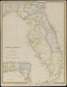
North America : Florida
7863.
North America
7864.
North America : performed under the patronage of Louis Duke of Orleans, First Prince of the Blood
7865.
North America
7866.
North America : from the French of Mr. d'Anville, improved with the back settlements of Virginia and course of Ohio,...
7867.
North America : corrected from the observation communicated to the Royal Society at London and the Royal Academy at Paris
7868.
North America
7869.
North America
7870.
North America
7871.
North America
7872.
North America, agreeable to the most approved maps and charts
7873.
North America, as divided amongst the European powers
7874.
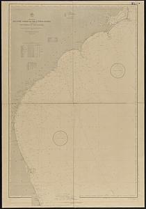
North America, Atlantic coast of the United States, Buzzard's Bay to Cape Lookout : compiled from the latest United States...
7875.
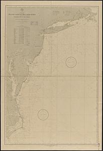
North America, Atlantic coast of the United States, Cape Canaveral to Havana with Straits of Florida and Bahama Banks :...
7876.
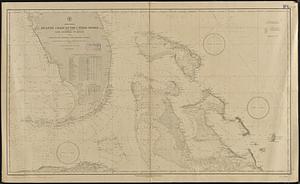
North America, Atlantic coast of the United States, Cape Hatteras to Cape Canaveral : compiled from the latest U.S. coast and...
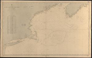
7877.
North America, Atlantic coast of the United States, Halifax to New York with southern part of Nova Scotia : compiled from the...
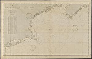
7878.
North America, Atlantic coast of the United States Halifax to New York with southern part of Nova Scotia : compiled from the...
7879.
North America, Bay of Fundy, Grand Manan Island and adjacent coast : from surveys by the British Admiralty in 1855, and by the...
7880.
North America divided into its III principall parts : 1st English part viz. English Empire containing ye Articklands near...
‹ Prev
Next ›
1
2
…
390
391
392
393
394
395
396
397
398
…
708
709