Toggle navigation
LMEC Home
Exhibitions
Georeferencing
Tools for Teachers
Collections
My Favorites
Sign Up / Log In
Search
Search the map portal
Map Collection
Map Collection
Map Sets
Search
Search
Search for
Search In
All Fields
Creator
Title
Subject
Place
Search All Digital Collections
Advanced Search
135 Results
My Search
Start Over
half
Remove constraint half
Filter your Search
Place
North and Central America
108
United States
94
Massachusetts
54
Boston
37
Suffolk (county)
35
Europe
10
Canada
9
World
9
more
Place
»
Topic
Boston (Mass.)--Maps
25
United States--Maps
9
World maps
6
Boston (Mass.)--Aerial views
5
Railroads--United States--Maps
3
Africa--Maps--Early works to 1800
2
Boston (England)--Maps
2
Boston (Mass.)--Buildings, structures, etc--Maps--Early works to 1800
2
more
Topic
»
Date
Date range begin
–
Date range end
Current results range from
1482
to
1988
View distribution
Creator
Sampson, Davenport & Co
10
Sampson, Murdock & Co
9
Amherst, Jeffery Amherst, Baron, 1717-1797
3
George, III, King of Great Britain, 1738-1820
3
George, IV, King of Great Britain, 1762-1830
3
O.H. Bailey & Co
3
Royal United Services Institute for Defence and Security Studies
3
Bachmann, John, fl. 1849-1885
2
more
Creator
»
Format
Maps/Atlases
132
Manuscripts
10
Prints
3
Georeferenced
Yes
23
No
112
Collection
Norman B. Leventhal Map & Education Center Collection
109
Boston and New England Maps
46
Urban Maps
41
American Revolutionary War-Era Maps
27
British Library Collection
8
Mapping Boston Collection
7
Library of Congress Collection
4
MacLean Collection Map Library
4
more
Collection
»
Available to use
No known restrictions
103
Creative Commons license
23
Search Constraints
Sort by relevance
relevance
title
date (asc)
date (desc)
Number of results to display per page
20 per page
10
per page
20
per page
50
per page
100
per page
View results as:
grid view
map view
Search Results
41.
The United States of America : including all its newly acquired territory
42.
Tosen zozu
43.
View of the city of New Bedford, Mass : 1876
44.
Sketch of Charleston Harbor
45.
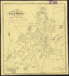
Plan of the central part of the city of Worcester
46.
Small circular world map
47.
Boston Highlands, Massachusetts : Wards 19, 20, 21 & 22 of Boston
48.
1903 Map of Salem and surrounding places
49.
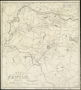
Map of the town of Newton
50.
Bird's eye view of the village of Hyannis, Barnstable County, Mass
51.
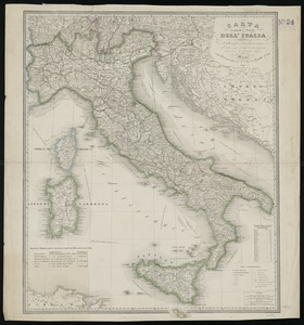
Carta geografica e postale dell' Italia ridotta dalle migliori carte fin' ora esistenti coll' indicazione di tutte le strade...
52.
A plan of Boston in New England with its environs : including Milton, Dorchester, Roxbury, Brooklin, Cambridge, Medford,...
53.
Map showing Boston territory tributary to South Metropolitan system and Boston main drainage system
54.
Map of Boston, for 1882
55.
Map of Boston, for 1883
56.
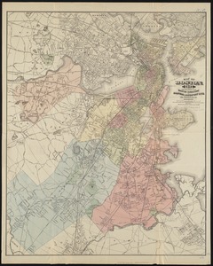
Map of Boston
57.
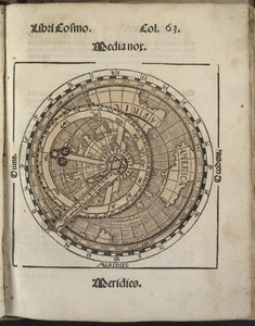
Diversi globi terr-aquei statione variante et visu intercedente, per coluros tropicorum, per ambos polos et particul : sphaerae...
58.
A plan of Boston in New England with its environs : including Milton, Dorchester, Roxbury, Brooklin, Cambridge, Medford,...
59.
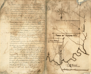
Survey plat of land grants on Caps River, Saint Domingue
60.
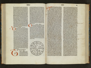
Unsigned and untitled T-O world map
‹ Prev
Next ›
1
2
3
4
5
6
7