Diversi globi terr-aquei statione variante et visu intercedente, per coluros tropicorum, per ambos polos et particul : sphaerae zenith in planum delineati orthographici prospectus
Item Information
- Title:
- Diversi globi terr-aquei statione variante et visu intercedente, per coluros tropicorum, per ambos polos et particul : sphaerae zenith in planum delineati orthographici prospectus
- Title (alt.):
-
Diversi globi terr-aqvei staione variante et visu intercedente, per coluros tropicorum, per ambos polos et particul. sphaerae zenith in planum delineati orthographici prospectus
- Description:
-
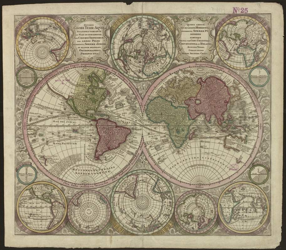
Seutter, one of the most important German globe makers and map publishers during the first half of the 18th century, created this world map using a design that was dominated by fourteen circles of varying sizes. It was included in the 1730 edition, as well as later editions, of his Atlas Novus. Starting with the basic design of two primary spheres depicting the traditional eastern and western hemispheres, Seutter added twelve subsidiary spheres. Rather than embellish the map's margins with ornate decorations, Seutter used these various spheres to provide different views of the Earth. Above and below the two primary spheres at the map's center are two smaller spheres depicting the northern and southern hemispheres. The corner spheres provide four different perspective views of the Earth as a globe which he identified as orthographic projections in the map's extended title. Despite this innovative format, most likely reflecting Seutter's interest in globe making, the geographic information was outdated. Like John Senex's map, California was still shown as an island, a concept that was disappearing from most mid-18th century maps.
- Creator:
- Seutter, Matthaeus, 1678-1756
- Name on Item:
-
Matth. Seutteri, S.C.M. Geogr.
- Date:
-
[1730]
- Format:
-
Maps/Atlases
- Location:
-
Boston Public Library
Norman B. Leventhal Map & Education Center - Collection (local):
-
Norman B. Leventhal Map & Education Center Collection
- Subjects:
-
World maps--Early works to 1800
- Places:
-
World
- Extent:
- 1 map : col. ; 54 x 61 cm.
- Terms of Use:
-
No known copyright restrictions.
No known restrictions on use.
- Publisher:
-
Augsburg :
M. Seutter
- Scale:
-
Scale not given.
- Language:
-
Latin
- Notes:
-
Relief shown pictorially.
Shows California as an island.
Exhibited in “Journeys of the Imagination,” at the Boston Public Library, Boston, MA, April - August 2006. MB (BRL)
- Notes (date):
-
This date is inferred.
- Identifier:
-
05_01_000224
- Call #:
-
G3200 1730 .S46
- Barcode:
-
39999052507017


