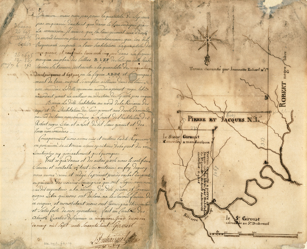
Survey plat of land grants on Caps River, Saint Domingue
This map is also available in American Revolutionary Geographies Online (ARGO), a collections portal especially built for material relating to the American Revolutionary War Era. Visit ARGO to learn more about this item and explore the historical geography of North America in the late eighteenth century.
Item Information
- Title:
- Survey plat of land grants on Caps River, Saint Domingue
- Description:
-
During the French colonial regime, Saint Domingue became one of the richest European colonies in the West Indies. Like many of the other islands, the economy focused on large sugar plantations, utilizing a sizeable importation of African slaves and taking advantage of fertile soils and an ideal climate. On the eve of the French revolution in 1784, there were approximately a half million slaves, outnumbering the free population 10-1. Life was harsh for the slaves but approximately 30,000 had gained freedom. These freed slaves were often mulattoes (children of French plantation owners and slave women) who had been granted freedom by their masters or black slaves who were able to purchase their freedom. Many of these slaves were able to acquire land, becoming wealthy, as indicated by this mid-18th-century survey plat, where Sieur Giroust granted land to Pierre and Jacques, identified as "negre libre." During the 1790s, there were numerous slave rebellions, finally resulting in the country's independence in 1804. The new republic was named Haiti, an original native name for the island.
- Date:
-
1768
- Format:
-
Maps/Atlases
- Location:
-
Boston Public Library
Rare Books Department - Collection (local):
-
Special Collections, Rare Books
- Subjects:
-
Land grants--Haiti--Maps, Manuscript--Early works to 1800
Haiti--Maps, Manuscript--Early works to 1800
- Places:
-
Haiti
- Extent:
- 1 ms. map ; 34 x 41 cm.
- Terms of Use:
-
No known copyright restrictions.
No known restrictions on use.
- Scale:
-
Scale not given
- Language:
-
French
- Notes:
-
Title supplied by cataloger.
Oriented with north to the bottom.
Featured in the Faces & Places Exhibit, Kravis Center, Palm Beach, FL, since 2005.
- Identifier:
-
05_04_000123
- Barcode:
-
39999054448590