Toggle navigation
LMEC Home
Exhibitions
Georeferencing
Tools for Teachers
Collections
My Favorites
Sign Up / Log In
Search
Search the map portal
Map Collection
Map Collection
Map Sets
Search
Search
Search for
Search In
All Fields
Creator
Title
Subject
Place
Search All Digital Collections
Advanced Search
58 Results
My Search
Start Over
Date
1745
Remove constraint Date: <span class='single'>1745</span>
Filter your Search
Place
North and Central America
42
Canada
25
Louisbourg
17
United States
9
North America
7
Africa
5
Nova Scotia
5
America
4
more
Place
»
Topic
Louisbourg (N.S.)--Maps, Manuscript--Early works to 1800
13
Louisbourg (N.S.)--History--Siege, 1745--Maps, Manuscript--Early works to 1800
12
Military maps--Early works to 1800
7
United States--History--King George’s War, 1744-1748--Maps, Manuscript--Early works to 1800
6
Austrian Succession, War of, 1740-1748--Maps, Manuscript--Early works to 1800
5
Military art and science--Nova Scotia--Louisbourg--Maps, Manuscript--Early works to 1800
5
Fortification--Nova Scotia--Louisbourg--Maps, Manuscript--Early works to 1800
4
Louisbourg (N.S.)--Maps
3
more
Topic
»
Date
1745
[remove]
58
Date range begin
–
Date range end
Current results range from
1699
to
1800
1745
to
1745
58
Creator
Bastide, John Henry, approximately 1700-1770
13
George, III, King of Great Britain, 1738-1820
11
George, IV, King of Great Britain, 1762-1830
11
Durell, Philip, -1766
8
Royal United Services Institute for Defence and Security Studies
8
Amherst, Jeffery Amherst, Baron, 1717-1797
7
Skinner, Monier
4
Skinner, William, 1700-1780
4
more
Creator
»
Format
Maps/Atlases
58
Manuscripts
15
Georeferenced
Yes
1
No
57
Collection
American Revolutionary War-Era Maps
39
British Library Collection
23
Norman B. Leventhal Map & Education Center Collection
19
William L. Clements Library Collection
10
MacLean Collection Map Library
2
Library of Congress Collection
1
Newberry Library Collection
1
Ralph Finos Map Collection at Phillips Academy
1
more
Collection
»
Available to use
Creative Commons license
25
No known restrictions
20
Search Constraints
Sort by relevance
relevance
title
date (asc)
date (desc)
Number of results to display per page
20 per page
10
per page
20
per page
50
per page
100
per page
View results as:
grid view
map view
Search Results
21.
A map of part of the Isthmus of Darien : shewing the communication with Panama, from Portobello & Chagre both by land, and by...
22.
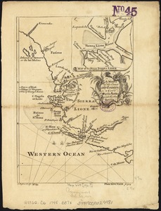
A map of the coast and country about Sierra Lione and Sherbro River
23.
Map of the coast and islands between Cape Roxo and the Isle of Tassagan
24.
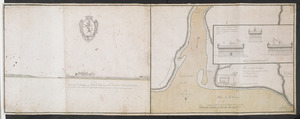
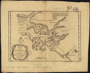
[Map showing Saint John's Harbour and a proposed fort]
25.
A new map of North America shewing its principal divisions, chief cities, townes, rivers, mountains &c
26.
A new map of the terraqueous globe according to the latest discoveries and most general divisions of it into continents and oceans
27.
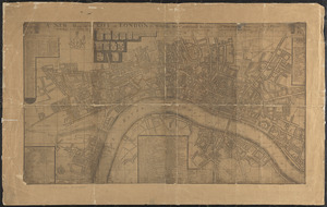
A new mapp of the city of London &c. with the many additionall buildings and new streets anno 1745 in a plain
28.
Nieuwe kaart van America uitgegeven te Amsterdam
29.
Nov[us] orbis sive America septentrionalis, divisa per sua regna provinc. et insul : cura et opera
30.
Part of modern Orange County
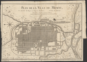
31.
Plan de la ville de Meaco
32.
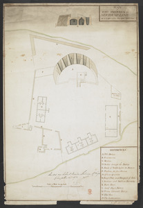
Plan du fort de Chouéghen de la Riviere Et de terrain aux Environs au Sud du Lac Ontario
33.
Plan du port et de la ville de Louisbourg : avec ses batteries et sa perspective, où est réprésenté les batteries faites...
34.
PLAN of FORT FREDERICK at NEWFOUND-LAND as it is now with the new Additions
35.
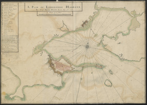
A PLAN OF LOUISBOUGH HARBOUR
36.
A plan of Louisbourg : intended only to shew by strong red the publick buildings lately erected; and by the faint red such as...
37.
Plan of Part of Black River & Part of Otter Creek with the Distances by Computation
38.
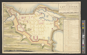
A PLAN OF THE CITY and FORTRESS OF LOUISBOURG
39.
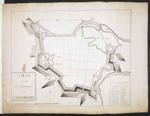
Plan of the City and Fortress of LOUISBOURG Surrendered to his Britanick Majesty by Capitulation the 17 June 1745. to Lieut....
40.
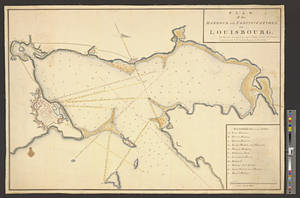
Plan of the harbour and fortifications of Louisbourg : the harbour survey'd by Capt. Phillip Durell: the town and...
‹ Prev
Next ›
1
2
3

![[Map showing Saint John's Harbour and a proposed fort]](https://bpldcassets.blob.core.windows.net/derivatives/images/commonwealth:6108vw12v/image_thumbnail_300.jpg)


![Nov[us] orbis sive America septentrionalis, divisa per sua regna provinc. et insul](https://bpldcassets.blob.core.windows.net/derivatives/images/commonwealth:wd376505f/image_thumbnail_300.jpg)