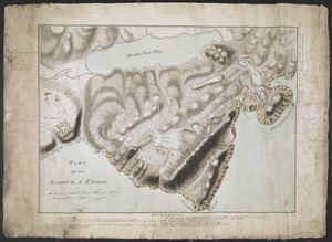
[Map showing Saint John's Harbour and a proposed fort]
![[Map showing Saint John's Harbour and a proposed fort]](https://bpldcassets.blob.core.windows.net/derivatives/images/commonwealth:6108vw12v/image_access_800.jpg)
This map is also available in American Revolutionary Geographies Online (ARGO), a collections portal especially built for material relating to the American Revolutionary War Era. Visit ARGO to learn more about this item and explore the historical geography of North America in the late eighteenth century.
Item Information
- Title:
- [Map showing Saint John's Harbour and a proposed fort]
- Former owner:
- Skinner, William, 1700-1780
- Former owner:
- Skinner, Monier
- Date:
-
[1745–1773]
- Format:
-
Maps/Atlases
- Location:
- British Library
- Collection (local):
-
British Library Collection
- Subjects:
-
Military art and science--Newfoundland and Labrador--St. John's--Maps, Manuscript--Early works to 1800
Fortification--Newfoundland and Labrador--St. John's--Maps, Manuscript--Early works to 1800
Harbors--Newfoundland and Labrador--St. John's--Maps, Manuscript--Early works to 1800
St. John's (N.L.)--Maps, Manuscript--Early works to 1800
- Places:
-
CanadaSaint John's
- Extent:
- 1 map on 3 sheets : joined, manuscript pen and ink with watercolour ; 56 x 93 cm
- Terms of Use:
-
No known copyright restrictions.
This work is licensed for use under a Creative Commons Attribution Non-Commercial Share Alike License (CC BY-NC-SA).

- Publisher:
-
[Saint John] :
[producer not identified]
- Scale:
-
Scale approximately 1:4,800
- Language:
-
English
- Catalog Record:
-
http://searcharchives.bl.uk/IAMS_VU2:IAMS040-002027386
- Notes:
-
Date range suggested on stylistic grounds and from (second) period of British occupation of Fort William beginning in 1745 to construction of Fort Townshend beginning in 1773.
Relief shown by hachuring.
Sounding depths are given.
Shows "Scale 400 Feet to an Inch" at lower right.
Shows Fort William (unnamed).
Shows a proposed, pentagonal fort west of Fort William (in the approximate location of Fort Townshend that was built in 1775).
A "Fort George" also existed east of Fort William (see - http://www.northamericanforts.com/Canada/nf.html#stjohns), but had been destroyed by time of this map's production.
Shows dotted lines in red ink and lettered points along the line (no key given) identifying strategic locations and routes?
Copy at Add Ms 33,231.II.1. 3 sheets joined comprising a roll. Laid on linen. Manuscript annotation at lower right in black ink, "Handed over to Lieut. Monier Skinner R. Eng.r by his father in 1872" and initialled (by William Skinner?). Red stamp of British Museum at lower right. Pressmark stamped to verso and repeated in pencil.
- Notes (date):
-
9999
This date is inferred.

![[Entrance to the Harbour of S.t Johns Newfoundland]](https://bpldcassets.blob.core.windows.net/derivatives/images/commonwealth:6108vv35z/image_thumbnail_300.jpg)
![[Map showing Saint John's Harbour with Fort William and Fort Townshend]](https://bpldcassets.blob.core.windows.net/derivatives/images/commonwealth:6108vv278/image_thumbnail_300.jpg)