Toggle navigation
LMEC Home
Exhibitions
Georeferencing
Tools for Teachers
Collections
My Favorites
Sign Up / Log In
Search
Search the map portal
Map Collection
Map Collection
Map Sets
Search
Search
Search for
Search In
All Fields
Creator
Title
Subject
Place
Search All Digital Collections
Advanced Search
98 Results
My Search
Start Over
g1105
Remove constraint g1105
Filter your Search
Place
North and Central America
85
United States
34
Canada
14
Quebec
8
South America
8
Cuba
6
North America
6
Pennsylvania
6
more
Place
»
Topic
North America--Maps--Early works to 1800
6
America--Discovery and Exploration--Maps--Early works to 1800
5
Québec (Québec)--Maps--Early works to 1800
5
Tactics--Maps--Early works to 1800
5
Braddock's Campaign, 1755--Maps
4
New England--Maps--Early works to 1800
4
United States--History--French and Indian War, 1754-1763--Maps
4
United States--History--French and Indian War, 1754-1763--Maps--Early works to 1800
4
more
Topic
»
Date
Date range begin
–
Date range end
Current results range from
1511
to
1777
View distribution
Creator
Jefferys, Thomas, -1771
76
Sayer, Robert, 1725-1794
66
Celi, Francisco Mathias
8
Le Rouge, Georges-Louis.
7
Green, John, -1757
6
Orme, Robert, -1781
6
Bellin, Jacques Nicolas, 1703-1772
2
Bully, le sieur
2
more
Creator
»
Format
Maps/Atlases
98
Georeferenced
Yes
1
No
97
Collection
Norman B. Leventhal Map & Education Center Collection
98
American Revolutionary War-Era Maps
68
Maritime Charts and Atlases
20
Boston and New England Maps
4
Urban Maps
2
Available to use
No known restrictions
98
Search Constraints
Sort by date (desc)
relevance
title
date (asc)
date (desc)
Number of results to display per page
20 per page
10
per page
20
per page
50
per page
100
per page
View results as:
grid view
map view
Search Results
21.
A general map of the middle British colonies in America : viz. Virginia, Maryland, Delaware, Pensilvania, New-Jersey, New-York,...
22.
The grand bay of Nipe on the north side of Cuba from Spanish draughts ; Plan of Puerto de Baracoa
23.
Guadaloupe, one of the Caribbee Islands subject to France in the West Indies
24.
The island and colony of Cayenne subject to the French, on the continent of South America
25.
The island of Hispaniola called by the French St. Domingo : subject to France & Spain
26.
Jamaica
27.
A map of Canada and the north part of Louisiana with the adjacent countrys
28.
A map of South Carolina and a part of Georgia : containing the whole sea-coast; all the islands, inlets, rivers, creeks,...
29.
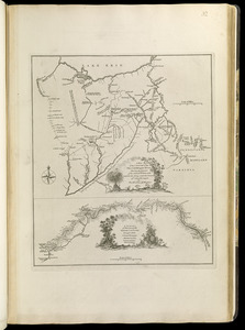
A map of the country between Will's Creek & Monongahela River shewing the rout and encampments of the English army in 1755
30.
A map of the country on the Ohio and Muskingum Rivers : shewing the situation of the Indian towns with respect to the army...
31.
A map of the discoveries made by the Russians on the North West coast of America
32.
A map of the island of Guadaloupe
33.
A map of the most inhabited part of Virginia containing the whole province of Maryland with part of Pensilvania, New Jersey and...
34.
A map of the n.e. part of Asia, and n.w. parts of America, shewing their situations with respect to Japan
35.
A map of the several dispositions of the English Fleet & Army on the River St. Laurence to the taking of Quebec
36.
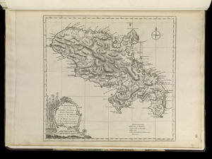
Martinico, one of the Caribbee Islands in the West Indies : subject to the French
37.
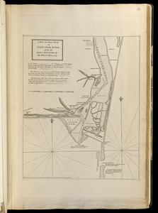
A new and exact plan of Cape Fear River, from the bar to Brunswick
38.
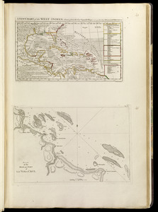
A new chart of the West Indies, drawn from the best Spanish maps, and regulated by astronomical observations ; Plan of the road...
39.
A new map of Nova Scotia, and Cape Britain : with the adjacent parts of New England and Canada, composed from a great number of...
40.
North America : from the French of Mr. d'Anville, improved with the back settlements of Virginia and course of Ohio,...
‹ Prev
Next ›
1
2
3
4
5