Toggle navigation
LMEC Home
Exhibitions
Georeferencing
Tools for Teachers
Collections
My Favorites
Sign Up / Log In
Search
Search the map portal
Map Collection
Map Collection
Map Sets
Search
Search
Search for
Search In
All Fields
Creator
Title
Subject
Place
Search All Digital Collections
Advanced Search
71 Results
My Search
Start Over
1697
Remove constraint 1697
Filter your Search
Place
North and Central America
24
North America
17
Europe
15
Africa
8
Saint Lawrence River
8
Canada
7
Cape Verde
6
South America
6
more
Place
»
Topic
North America--Maps--Early works to 1800
9
North America--Maps
8
Saint Lawrence River--Maps, Manuscript--Early works to 1800
4
South America--Maps
4
Fortification--Ontario, Lake (N.Y. and Ont.)--Maps, Manuscript--Early works to 1800
3
Ontario, Lake (N.Y. and Ont.)--Maps, Manuscript--Early works to 1800
3
Saint Lawrence River--Maps
3
Swedish-Polish War, 1655-1660--Maps--Early works to 1800
3
more
Topic
»
Date
Date range begin
–
Date range end
Current results range from
1689
to
1891
View distribution
Creator
Anville, Jean Baptiste Bourguignon d', 1697-1782
33
Coronelli, Vincenzo, 1650-1718
10
Dahlbergh, Erik Jönsson, greve, 1625-1703
8
Pufendorf, Samuel, Freiherr von, 1632-1694
8
Riegel, Christoph
8
Swidde, Willem, 1660 or 1661-1697
8
Labrosse, Paul, 1697-1769
7
Royal United Services Institute for Defence and Security Studies
7
more
Creator
»
Format
Maps/Atlases
66
Prints
5
Manuscripts
1
Georeferenced
Yes
6
No
65
Collection
Norman B. Leventhal Map & Education Center Collection
50
American Revolutionary War-Era Maps
27
British Library Collection
7
New York Public Library Collection
5
American Antiquarian Society Collection
3
MacLean Collection Map Library
2
Massachusetts Historical Society Map Collection
2
Boston and New England Maps
1
more
Collection
»
Available to use
No known restrictions
50
Creative Commons license
15
Search Constraints
Sort by relevance
relevance
title
date (asc)
date (desc)
Number of results to display per page
20 per page
10
per page
20
per page
50
per page
100
per page
View results as:
grid view
map view
Search Results
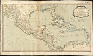
21.
A new and complete map of the West Indies : comprehending all the coasts and islands known by that name
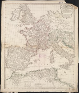
22.
Orbis Romani pars occidentalis : auspiciis serenissimi principis Ludovici Philippi Aurelianorum ducis publici juris facta
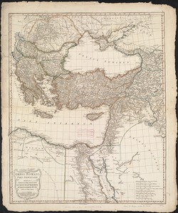
23.
Orbis Romani pars orientalis : auspiciis serenissimi principis Ludovici Philippi Aurelianorum ducis publici juris facta
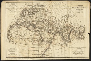
24.
Orbis veteribus notus
25.
Orbis veteribus notus scilicet: Europe, Asia, Africa publici juris factus
26.
Partie orientale du Canada, avec la Nouvelle Angleterre, l'Acadie, et la Terre-Neuve
27.
Amérique méridionale : publiée sous les auspices de Monseigneur le Duc d'Orleans prémier prince du Sang
28.
Canada, Louisiane et terres angloises
29.
Canada, Louisiane et terres angloises
30.
Canada, Louisiane et terres angloises
31.
North America from the French of Mr. D'Anville, improved with the back settlements of Virginia and course of Ohio, illustrated...
32.
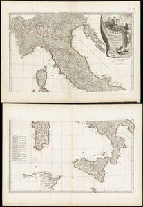
L'Italie : publiée sous les auspices de Monseigneur le Duc d'Orleans, Prémier Prince du Sang
33.
[Map showing the location of Fort de la Presentation]
34.
A New map of the whole continent of America, divided into North and South and West Indies. : With a descriptive account of the...
35.
A New map of the whole continent of America, divided into North and South and West Indies. : Wherein are exactly described the...
36.
North America : from the French of Mr. d'Anville, improved with the back settlements of Virginia and course of Ohio,...
37.
Second part of Asia : being China, part of India and Tartary, the islands of Sonda, Molucka, Philippin, Japan &c. ; performed...
38.
A new and accurate map of North America
39.
Eiland van St. Filippus, of van Fuego, met zyn vuurberg = Ile de St. Philipe ou de Fuego avec son volcan
40.
Gezigt van Porto Grande, in 't eiland St. Vincent = Vüe de Porto Grande dans l'ile de St. Vincent
‹ Prev
Next ›
1
2
3
4


![[Map showing the location of Fort de la Presentation]](https://bpldcassets.blob.core.windows.net/derivatives/images/commonwealth:hx11z0993/image_thumbnail_300.jpg)


