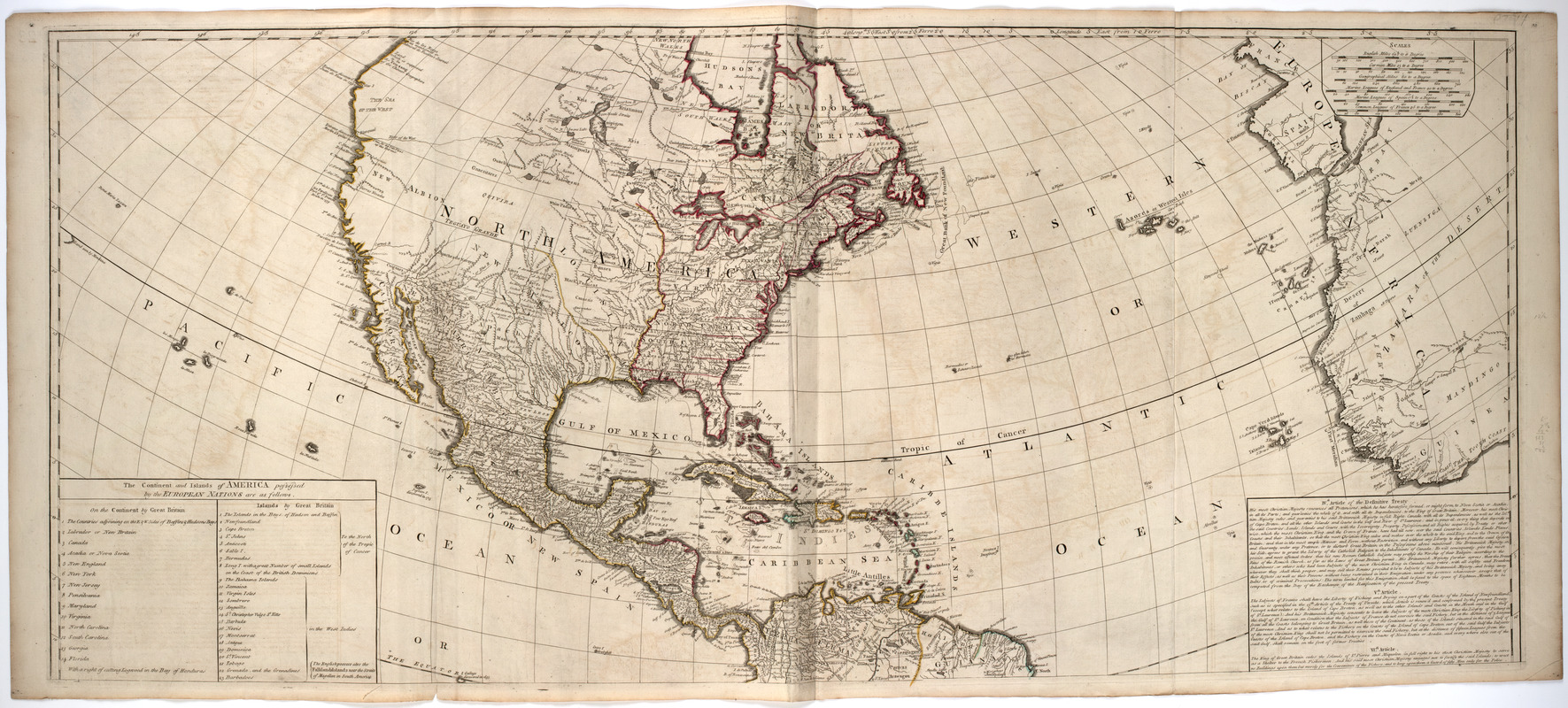
A New map of the whole continent of America, divided into North and South and West Indies. : Wherein are exactly described the United States of North America as well as the several European possessions according to the preliminaries of peace signed at Versailles Jan. 20, 1783

This map is also available in American Revolutionary Geographies Online (ARGO), a collections portal especially built for material relating to the American Revolutionary War Era. Visit ARGO to learn more about this item and explore the historical geography of North America in the late eighteenth century.
Item Information
- Title:
- A New map of the whole continent of America, divided into North and South and West Indies. : Wherein are exactly described the United States of North America as well as the several European possessions according to the preliminaries of peace signed at Versailles Jan. 20, 1783
- Description:
-
Subject: Map of the Western Hemisphere. Includes cartouche at bottom right with a native headpiece and quiver, a beaver and a crocodile or alligator, set in a landscape.
- Creator:
- Anville, Jean Baptiste Bourguignon d', 1697-1782
- Donor:
- Frost, Donald McKay, 1877-1958
- Publisher:
- Sayer, Robert
- Name on Item:
-
compiled from Mr. d'Anville's maps of that continent, with the addition of the Spanish discoveries in 1775 to the north of California & corrected in the several parts belonging to Great Britain from the original materials of Governor Pownall, M.P.
- Date:
-
1786
- Format:
-
Maps/Atlases
- Location:
- American Antiquarian Society
- Collection (local):
-
American Antiquarian Society Collection
- Subjects:
-
North America--Maps
South America--Maps
- Places:
-
North America (area)
South America
- Extent:
- 1 map on 4 sheets : engraving, hand colored ; 104 x 119 cm., on sheets 55 x 62 cm. or smaller
- Terms of Use:
-
Public Domain/No known restrictions on use. Contact host institution to download image.
Contact host institution for more information.
- Publisher:
-
London :
Printed for Robt. Sayer, map, chart & printseller, no. 53 Fleet Street, as the Act directs
- Scale:
-
Scale [ca. 1:12,000,000]
- Language:
-
English
- Catalog Record:
-
http://catalog.mwa.org/vwebv/holdingsInfo?bibId=480615
- Notes:
-
Prime meridian: Ferro.
Relief shown pictorially.
Inset: The supplement to North America containing the countries adjoining to Baffins & Hudsons bays.
"The continent and islands of America possessed by the European nations are as follows ... "


