Toggle navigation
LMEC Home
Exhibitions
Georeferencing
Tools for Teachers
Collections
My Favorites
Sign Up / Log In
Search
Search the map portal
Map Collection
Map Collection
Map Sets
Search
Search
Search for
Search In
All Fields
Creator
Title
Subject
Place
Search All Digital Collections
Advanced Search
460 Results
My Search
Start Over
Date
1700
to
1749
Remove constraint Date: <span class='from'>1700</span> to <span class='to'>1749</span>
Filter your Search
Place
North and Central America
272
United States
116
Europe
69
Canada
64
North America
53
South America
48
Africa
39
France
22
more
Place
»
Topic
North America--Maps--Early works to 1800
29
Manuscript maps--Early works to 1800
24
America--Maps--Early works to 1800
19
Western Hemisphere--Maps--Early works to 1800
19
South America--Maps--Early works to 1800
16
Louisbourg (N.S.)--Maps, Manuscript--Early works to 1800
14
Louisbourg (N.S.)--History--Siege, 1745--Maps, Manuscript--Early works to 1800
13
West Indies--Maps--Early works to 1800
12
more
Topic
»
Date
1700
to
1749
[remove]
460
Date range begin
–
Date range end
Current results range from
1668
to
1800
1700
to
1704
53
1705
to
1709
50
1710
to
1714
57
1715
to
1719
50
1720
to
1724
59
1725
to
1729
44
1730
to
1734
75
1735
to
1739
90
1740
to
1744
77
1745
to
1749
125
Creator
Moll, Herman, d. 1732
60
George, III, King of Great Britain, 1738-1820
40
George, IV, King of Great Britain, 1762-1830
39
L'Isle, Guillaume de, 1675-1726
25
Bellin, Jacques Nicolas, 1703-1772
17
Royal United Services Institute for Defence and Security Studies
17
Bastide, John Henry, approximately 1700-1770
15
Bowles, John, 1701-1779
14
more
Creator
»
Format
Maps/Atlases
451
Manuscripts
70
Drawings/Illustrations
5
Prints
3
Georeferenced
Yes
25
No
435
Collection
Norman B. Leventhal Map & Education Center Collection
300
American Revolutionary War-Era Maps
129
British Library Collection
73
Maritime Charts and Atlases
46
Boston and New England Maps
33
William L. Clements Library Collection
28
Newberry Library Collection
22
Urban Maps
17
more
Collection
»
Available to use
No known restrictions
296
Creative Commons license
102
Search Constraints
Sort by relevance
relevance
title
date (asc)
date (desc)
Number of results to display per page
20 per page
10
per page
20
per page
50
per page
100
per page
View results as:
grid view
map view
Search Results
281.
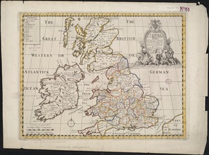
A new map of the Brittish Isles shewing their present genl. divisions, cities, and such other towns, or places, as answer to...
282.
A new map of the country of Louisiana and of ye river Missisipi in North America discou'd by Mons. de la Salle in ye years...
283.
A new map of the English empire in America viz. Virginia, Maryland, Carolina, Pennsylvania, New York, New Iarsey, New England,...
284.
A new map of the most considerable plantations of the English in America
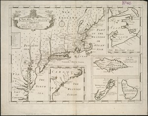
285.
A new map of the most considerable plantations of the English in America
286.
A new map of the north part of antient Africa shewing the chiefe people, cities, towns, rivers, mountains, &c. in Mauritania,...
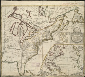
287.
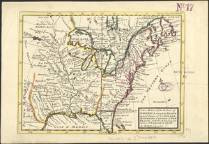
A new map of the north parts of America claimed by France under ye names of Louisiana, Mississipi, Canada, and New France with...
288.
A new map of the north parts of America claimed by France under ye names of Louisiana, Mississipi, Canada, and New France with...
289.
A new map of the north parts of America claimed by France under ye names of Louisiana, Mississipi, Canada, and New France with...
290.
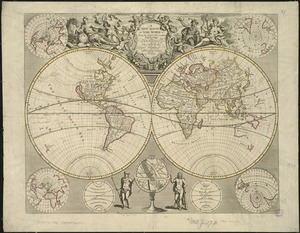
A new map of the terraqueous globe according to the ancient discoveries and most general divisions of it into continents and...
291.
A new map of the terraqueous globe according to the latest discoveries and most general divisions of it into continents and oceans
292.
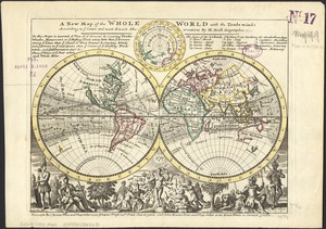
A new map of the whole world with the trade winds according to ye latest and most exact observations
293.
A new map of the world according to Wrights alias Mercators projection &c : drawn from the newest and the most exact...
294.
A new map of the world from the latest observations
295.
A new map of Virginia, Mary-land and the improved parts of Penn-sylvania & New Jersey
296.
A new map of ye north parts of America claimed by France under ye names of Louisiana, Mississipi, Canada & new France with the...
297.
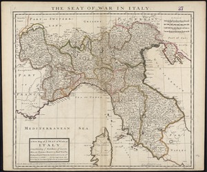
A new map of ye seat of war in Italy : comprehending ye Dutchies of Savoy, Milan, Parma Mantua, Modna., Tuscny., &c. : the...
298.
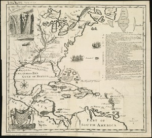
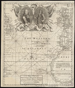
A new map or chart of the Western or Atlantic Ocean, with part of Europe Africa & America : showing the course of galleons,...
299.
A new mapp of Carolina
300.
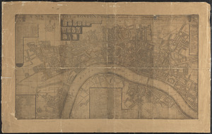
A new mapp of the city of London &c. with the many additionall buildings and new streets anno 1745 in a plain
‹ Prev
Next ›
1
2
…
11
12
13
14
15
16
17
18
19
…
22
23