Toggle navigation
LMEC Home
Exhibitions
Georeferencing
Tools for Teachers
Collections
My Favorites
Sign Up / Log In
Search
Search the map portal
Map Collection
Map Collection
Map Sets
Search
Search
Search for
Search In
All Fields
Creator
Title
Subject
Place
Search All Digital Collections
Advanced Search
952 Results
My Search
Start Over
More Like
commonwealth-oai:xg94nq67c
Remove constraint More Like: commonwealth-oai:xg94nq67c
Filter your Search
Place
North and Central America
912
United States
637
Canada
220
New York
193
Quebec
114
Saint Lawrence River
66
Pennsylvania
60
New Jersey
54
more
Place
»
Topic
United States--History--Revolution, 1775-1783--Maps
305
United States--History--French and Indian War, 1754-1763--Maps
162
Saint Lawrence River--Maps
67
Newport (R.I.)--Maps
27
Québec (Québec)--Maps
27
New York (State)--Maps
25
Hudson River (N.Y. and N.J.)--Maps
21
Louisbourg (N.S.)--Maps
20
more
Topic
»
Date
Date range begin
–
Date range end
Current results range from
1700
to
1900
View distribution
Creator
Jefferys, Thomas, -1771
30
Holland, Samuel, 1728-1801
29
Montrésor, John, 1736-1799
29
Rocque, Mary Ann
29
Bellin, Jacques Nicolas, 1703-1772
28
Clinton, Henry, Sir, 1738?-1795
19
Robert Sayer and John Bennett (Firm)
16
Orme, Robert, -1781
14
more
Creator
»
Format
Maps/Atlases
936
Drawings/Illustrations
11
Documents
5
Manuscripts
1
Prints
1
Georeferenced
No
952
Collection
American Revolutionary War-Era Maps
947
William L. Clements Library Collection
909
Library and Archives Canada Collection
18
Norman B. Leventhal Map & Education Center Collection
9
American Antiquarian Society Collection
5
Richard H. Brown Revolutionary War Map Collection at Mount Vernon
4
MacLean Collection Map Library
3
New York Public Library Collection
3
more
Collection
»
Available to use
No known restrictions
10
Creative Commons license
7
Search Constraints
Sort by relevance
relevance
title
date (asc)
date (desc)
Number of results to display per page
20 per page
10
per page
20
per page
50
per page
100
per page
View results as:
grid view
map view
Search Results
181.
Western shore of Jesus Island and Mille Îles River
182.
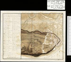
Map of Quebec City with plans of the citadel by Captain Samuel Holland for Report of the government of Quebec and dependencies
183.
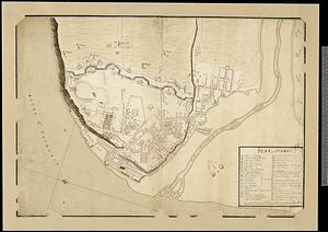
Plan of Quebec
184.
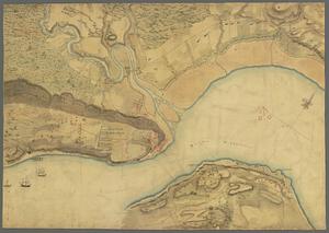
Plan of the town of Quebec the capital of Canada in North America : with the bason and a part of the adjacent country shewing...
185.
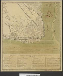
Plan of the town of Quebeck in Canada enlarged from Bellin’s plan with additions
186.
Canada, Louisiane et terres angloises
187.
Canada, Louisiane et terres angloises
188.
Canada, Louisiane et terres angloises
189.
A chart of Canada River : from ye island of Anticosty as far up as Quebeck, ye islands, locks, shoals, & soundings as they...
190.
Cours du fleuve St. Laurent : deuxieme feuille : depuis Quebec jusqu'au havre des Papinachouas
191.
Cours du fleuve St. Laurent : premiere feuille : contenant depuis le Lac Ontario jusqu'a Quebec
192.
Cours du fleuve St. Laurent : troisieme feuille : depuis le mont Camille jusqu'a l'isle d'Anticosti
193.
Iroquois or St. Lawrence
194.
A map of part of Canada for the use of His Majesty's Secretary of State, compiled in the Surveyor Generals Office, pursuant to...
195.
A map of the several dispositions of the English fleet & army on the river S.t Laurence, to the taking of Quebec
196.
A new map of the province of Quebec, : according to the Royal proclamation, of the 7th of October 1763
197.
A new map of the province of Quebec, : according to the Royal proclamation, of the 7th of October 1763
198.
Plan of Canada or the province of Quebec from the uppermost settlements to the island of Coudre as surveyed by order of his...
199.
A plan of the River St. Laurence from Green Island to Cape Carrouge
200.
Plan of the river St Lawrence fom the Island of Anticosta to Quebec ... from a manuscript found on board ye Alcide taken June...
‹ Prev
Next ›
1
2
…
6
7
8
9
10
11
12
13
14
…
47
48