Toggle navigation
LMEC Home
Exhibitions
Georeferencing
Tools for Teachers
Collections
My Favorites
Sign Up / Log In
Search
Search the map portal
Map Collection
Map Collection
Map Sets
Search
Search
Search for
Search In
All Fields
Creator
Title
Subject
Place
Search All Digital Collections
Advanced Search
987 Results
My Search
Start Over
More Like
commonwealth-oai:v405x789b
Remove constraint More Like: commonwealth-oai:v405x789b
Filter your Search
Place
North and Central America
959
United States
695
Canada
206
New York
194
Quebec
111
Rhode Island
83
Massachusetts
77
Pennsylvania
61
more
Place
»
Topic
United States--History--Revolution, 1775-1783--Maps
330
United States--History--French and Indian War, 1754-1763--Maps
149
Rhode Island--Maps
50
Saint Lawrence River--Maps
43
Massachusetts--Maps
40
Newport (R.I.)--Maps
28
Connecticut--Maps
26
New York (State)--Maps
25
more
Topic
»
Date
Date range begin
–
Date range end
Current results range from
1700
to
1981
View distribution
Creator
Rocque, Mary Ann
29
Holland, Samuel, 1728-1801
25
Jefferys, Thomas, -1771
25
Montrésor, John, 1736-1799
25
Bellin, Jacques Nicolas, 1703-1772
24
Clinton, Henry, Sir, 1738?-1795
19
Robert Sayer and John Bennett (Firm)
16
Hills, John, active 1777-1819
13
more
Creator
»
Format
Maps/Atlases
971
Drawings/Illustrations
11
Documents
5
Manuscripts
4
Objects/Artifacts
1
Prints
1
Georeferenced
Yes
17
No
970
Collection
American Revolutionary War-Era Maps
934
William L. Clements Library Collection
909
Norman B. Leventhal Map & Education Center Collection
56
Boston and New England Maps
43
American Antiquarian Society Collection
9
David Judkins Weaver Papers
4
Newberry Library Collection
3
Urban Maps
3
more
Collection
»
Available to use
No known restrictions
57
Creative Commons license
5
Search Constraints
Sort by relevance
relevance
title
date (asc)
date (desc)
Number of results to display per page
20 per page
10
per page
20
per page
50
per page
100
per page
View results as:
grid view
map view
Search Results
361.
A topographical map of the state of Rhode-Island and Providence Plantations
362.
Tri-state trolley map showing Boston & Northern and Old Colony Street Railway Companies' systems and connecting lines
363.
An accurate map of the United States of America : according to the Treaty of Peace of 1783
364.
Atlas to Marshall's life of Washington
365.
Boston its environs and harbour, : with the rebels works raised against that town in 1775, from the observations of Lieut. Page...
366.
Boston with its environs
367.
Carte de l'affaire de Montmouth, ou le Général Washington commandon l'armée Americaine, et le Général Clinton l'armée...
368.
Carte du theatre de la guerre presente en Amerique
369.
Carte nouvelle des posséssions angloises en Amérique dressée pour l'intelligence de la guerre présente et divisée suivant les...
370.
Centennial map of Concord, 1775-1875
371.
[Chart of Boston Harbor and the surrounding areas]
372.
Gen. Washington's Revolutionary campaign war map : after a survey ordered by him showing the position of his army in defence of...
373.
Map of American camp in New Jersey and surrounding countryside
374.
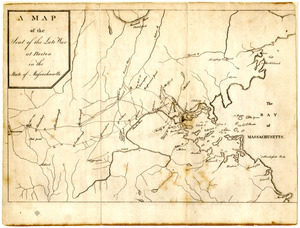
Map of the seat of the late war at Boston in the state of Massachusetts
375.
A Map of the seat of the late war at Boston in the state of Massachusetts
376.
Map of the vicinity of Yorktown, Virginia, 1881
377.
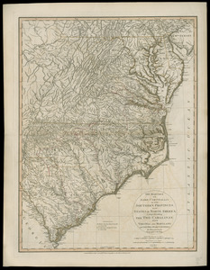
The marches of Lord Cornwallis in the Southern Provinces, now states of North America : comprehending the two Carolinas, with...
378.
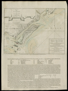
A Plan of Charles Town the capitol of South Carolina, : with the harbour, islands, and forts; the attack on Fort Sulivan, by...
379.
A plan of the attack of Fort Sulivan, near Charles Town in South Carolina : by a squadron of His Majesty's ships, on the 28th....
380.
A plan of the entrance of Chesapeak Bay, with James and York Rivers : wherein are shown the respective positions (in the...
‹ Prev
Next ›
1
2
…
15
16
17
18
19
20
21
22
23
…
49
50


![[Chart of Boston Harbor and the surrounding areas]](https://bpldcassets.blob.core.windows.net/derivatives/images/commonwealth:6108vs71d/image_thumbnail_300.jpg)