Toggle navigation
LMEC Home
Exhibitions
Georeferencing
Tools for Teachers
Collections
My Favorites
Sign Up / Log In
Search
Search the map portal
Map Collection
Map Collection
Map Sets
Search
Search
Search for
Search In
All Fields
Creator
Title
Subject
Place
Search All Digital Collections
Advanced Search
953 Results
My Search
Start Over
More Like
commonwealth-oai:st74hp42z
Remove constraint More Like: commonwealth-oai:st74hp42z
Filter your Search
Place
North and Central America
913
United States
637
Canada
221
New York
193
Quebec
114
Saint Lawrence River
66
Pennsylvania
60
New Jersey
54
more
Place
»
Topic
United States--History--Revolution, 1775-1783--Maps
305
United States--History--French and Indian War, 1754-1763--Maps
162
Saint Lawrence River--Maps
67
Newport (R.I.)--Maps
27
Québec (Québec)--Maps
27
New York (State)--Maps
25
Hudson River (N.Y. and N.J.)--Maps
21
Louisbourg (N.S.)--Maps
20
more
Topic
»
Date
Date range begin
–
Date range end
Current results range from
1700
to
1900
View distribution
Creator
Jefferys, Thomas, -1771
30
Holland, Samuel, 1728-1801
29
Montrésor, John, 1736-1799
29
Rocque, Mary Ann
29
Bellin, Jacques Nicolas, 1703-1772
28
Clinton, Henry, Sir, 1738?-1795
19
Robert Sayer and John Bennett (Firm)
16
Orme, Robert, -1781
14
more
Creator
»
Format
Maps/Atlases
937
Drawings/Illustrations
11
Documents
5
Manuscripts
1
Prints
1
Georeferenced
No
953
Collection
American Revolutionary War-Era Maps
948
William L. Clements Library Collection
909
Library and Archives Canada Collection
19
Norman B. Leventhal Map & Education Center Collection
9
American Antiquarian Society Collection
5
Richard H. Brown Revolutionary War Map Collection at Mount Vernon
4
MacLean Collection Map Library
3
New York Public Library Collection
3
more
Collection
»
Available to use
No known restrictions
10
Creative Commons license
7
Search Constraints
Sort by relevance
relevance
title
date (asc)
date (desc)
Number of results to display per page
20 per page
10
per page
20
per page
50
per page
100
per page
View results as:
grid view
map view
Search Results
821.
Richmond
822.
River valley with several foothills and swamp
823.
La rivière du Détroit depuis le Lac Sainte Claire jusqu'au Lac Erié
824.
The road from New Bridge and Hackinsack to Burlington
825.
Roads from Windsor to Easton through the highlands
826.
A rough draught of New Haven fort
827.
Rough Scetch of the King's Domain at Detroit
828.
A rude sketch of a part of the road between the township of Horton and Granville on the river of Annapolis, relative to a...
829.
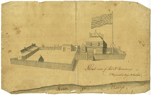
S. east view of Fort St. Tammany : N. Hayward to Major H. Burbeck
830.
Saml Wath to Abel Richardson : Wm Foster to James Foster exec ditto
831.
Sandy Hook, New Jersey
832.
Savannah and its defenses
833.
Savannah River and Savannah Sound
834.
A scetch [sic] of that part of Statten island from the Old Star [Ferry] to Deckers Ferry and the lands lying to the westd. of...
835.
Schauplatz des kriegs zwischen Engelland und seinen collonien in America nach richtigen carten gezeichnet und in diese form...
836.
The seat of action between the British and American forces or an authentic plan of Staten Island with the neighbouring...
837.
The seat of action, between the British and American forces or an authentic plan of the western part of Long Island, with the...
838.
Seat of war in the environs of Philadelphia
839.
Seconnet Passage
840.
Section of the level of the country
‹ Prev
Next ›
1
2
…
38
39
40
41
42
43
44
45
46
47
48


![A scetch [sic] of that part of Statten island from the Old Star [Ferry] to Deckers Ferry and the lands lying to the westd. of the road leading from Deckers Ferry to the Old Star made from a view of the same by Thomas Millidge major of the 5th battn. of N: J V](https://bpldcassets.blob.core.windows.net/derivatives/metadata/commonwealth-oai:1831hj84z/image_thumbnail_300.jpg)