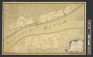
La rivière du Détroit depuis le Lac Sainte Claire jusqu'au Lac Erié

This map is also available in American Revolutionary Geographies Online (ARGO), a collections portal especially built for material relating to the American Revolutionary War Era. Visit ARGO to learn more about this item and explore the historical geography of North America in the late eighteenth century.
Item Information
- Title:
- La rivière du Détroit depuis le Lac Sainte Claire jusqu'au Lac Erié
- Title (alt.):
-
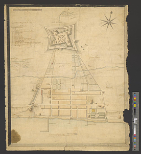
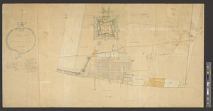
Plan du fort du Détroit
- Creator:
- Bellin, Jacques Nicolas, 1703-1772
- Creator:
- Chaussegros de Léry, Joseph Gaspard, 1721-1797
- Date:
-
[1764]
- Format:
-
Maps/Atlases
- Location:
- William L. Clements Library
- Collection (local):
-
William L. Clements Library Collection
- Subjects:
-
Detroit River (Mich. and Ont.)--Maps
Detroit (Mich.)--Maps
Fort Detroit (Detroit, Mich.)--Maps
- Places:
-
Detroit River
MichiganWayne (county)Detroit
- Extent:
- 1 map : col. ; 21 x 32 cm
- Terms of Use:
-
The University of Michigan Library provides access to these materials for educational and research purposes. These materials may be under copyright. If you decide to use any of these materials, you are responsible for making your own legal assessment and securing any necessary permission. If you have questions about the collection, please contact the William L. Clements Library.
Contact host institution for more information.
- Place of origin:
-
[Paris]
- Scale:
-
Scale of leagues.
- Language:
-
French
- Catalog Record:
-
Catalog record
- Notes:
-
Inset shows ground plan of fortified town with major buildings identified in table of references.
Above neat line at right: Tome 1 no. 12.
From: Bellin, Jacques Nicolas. Le petit atlas maritime ..., 1764.
Based on maps done by Chaussegros de Léry in 1749.
- Notes (date):
-
This date is inferred.
- Identifier:
-
190
- Barcode:
-
B1937290