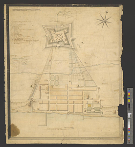
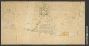
Rough Scetch of the King's Domain at Detroit
This map is also available in American Revolutionary Geographies Online (ARGO), a collections portal especially built for material relating to the American Revolutionary War Era. Visit ARGO to learn more about this item and explore the historical geography of North America in the late eighteenth century.
Item Information
- Title:
- Rough Scetch of the King's Domain at Detroit
- Title (alt.):
-
Rough Sketch of the King's Domain at Detroit
- Creator:
- Smith, David William, Sir, 1764-1837
- Name on Item:
-
D.W. Smith, Actg. Fort Adjutant
- Date:
-
September 1790
- Format:
-
Maps/Atlases
- Genre:
-
Manuscript maps
- Location:
- William L. Clements Library
- Collection (local):
-
William L. Clements Library Collection
- Subjects:
-
Fort Lernoult (Detroit, Mich.)--Maps
Detroit (Mich.)--Maps
- Places:
-
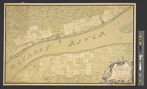
MichiganWayne (county)Detroit
- Extent:
- 1 manuscript map : colored ; 54.5 x 101 cm
- Terms of Use:
-
The University of Michigan Library provides access to these materials for educational and research purposes. These materials may be under copyright. If you decide to use any of these materials, you are responsible for making your own legal assessment and securing any necessary permission. If you have questions about the collection, please contact the William L. Clements Library.
Contact host institution for more information.
- Scale:
-
Scale approximately 1:1,584.
- Language:
-
English
- Catalog Record:
-
Catalog record
- Notes:
-
North oriented toward upper right.
Relief shown pictorially.
"2 chains per an inch."
Pencil, ink and wash map shows ground plan of Fort Lernoult and adjacent areas.
Shows "some graves" outside of the fort near the road, possibly of Donald Campbell and James Dalyell, both d. 1763.
Several locations labeled with letters; key lacking.
Map hung in a Montréal tavern in the 1930s.
- Identifier:
-
8700
- Barcode:
-
B8261342