Toggle navigation
LMEC Home
Exhibitions
Georeferencing
Tools for Teachers
Collections
My Favorites
Sign Up / Log In
Search
Search the map portal
Map Collection
Map Collection
Map Sets
Search
Search
Search for
Search In
All Fields
Creator
Title
Subject
Place
Search All Digital Collections
Advanced Search
950 Results
My Search
Start Over
More Like
commonwealth-oai:s4659g03n
Remove constraint More Like: commonwealth-oai:s4659g03n
Filter your Search
Place
North and Central America
924
United States
664
New York
232
Canada
205
Quebec
111
Pennsylvania
61
New Jersey
57
Manhattan
51
more
Place
»
Topic
United States--History--Revolution, 1775-1783--Maps
305
United States--History--French and Indian War, 1754-1763--Maps
149
Manhattan (New York, N.Y.)--Maps
51
Saint Lawrence River--Maps
43
New York (N.Y.)--Maps
27
Newport (R.I.)--Maps
27
New York (State)--Maps
24
Hudson River (N.Y. and N.J.)--Maps
21
more
Topic
»
Date
Date range begin
–
Date range end
Current results range from
1700
to
1939
View distribution
Creator
Rocque, Mary Ann
29
Holland, Samuel, 1728-1801
25
Montrésor, John, 1736-1799
25
Bellin, Jacques Nicolas, 1703-1772
24
Jefferys, Thomas, -1771
24
Clinton, Henry, Sir, 1738?-1795
19
Robert Sayer and John Bennett (Firm)
15
Hills, John, active 1777-1819
13
more
Creator
»
Format
Maps/Atlases
934
Drawings/Illustrations
11
Documents
5
Manuscripts
1
Prints
1
Georeferenced
Yes
8
No
942
Collection
American Revolutionary War-Era Maps
911
William L. Clements Library Collection
909
Norman B. Leventhal Map & Education Center Collection
38
Urban Maps
26
New-York Historical Society Collection
2
New York Public Library Collection
1
Available to use
No known restrictions
40
Creative Commons license
1
Search Constraints
Sort by relevance
relevance
title
date (asc)
date (desc)
Number of results to display per page
20 per page
10
per page
20
per page
50
per page
100
per page
View results as:
grid view
map view
Search Results
881.
St. Eustatia topographically drawn & humbly dedicated to his excellency John Vaughan commander in chief of his majestys forces...
882.
The St. Lawrence River between Coteau des Cedres and Varennes
883.
The St. Lawrence River between Trois Rivières and Grondines Parish
884.
The St. Lawrence River from the Rapids of Richelieu to Cape Torment
885.
St. Paul's Bay; Isle de Coudres; Great Cove; Pt. de Mille Vaches
886.
Stony Point
887.
Subdivision of lot no. 12 in the Good Beer Kill tract : performed this 4th day of Octr. 1797
888.
Sullivans Island
889.
Survey bill of Peter Hams farm, (as he now has the same in fence) situate in great lot no. 2 in the manor of Livingston :...
890.
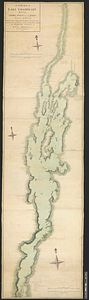
A survey of Lake Champlain including Crown Point and St: John's : surveyed by order of his excellency Major Genl: Sir Jeffery...
891.
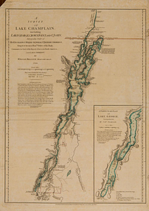
A survey of Lake Champlain, including Lake George, Crown Point and St. John : surveyed by order of his excellency Major-General...
892.
Survey of land between Kennebec River and Wesserunsett Pond, Maine
893.
A survey of the city and fortress of Louisbourg, the harbour, and their environs, from Fresh Water Cove in Gabarouse Bay to...
894.
A survey of the passage to the river Missisippi by the Lakes Pontchartrain and Maurepas and the river Iberville : 10th January...
895.
A survey of the peninsula of Charles Town shewing the three posts now garrison'd by his majesty's troops for the winter : 10th...
896.
Survey of the wharf lots lying between Broad and Queen streets, to ascertain the line, between Mr. Samuel Prideau junior & Mr....
897.
Survey on Red River
898.
Surveyed by Daniel Newhall for Capt Caleb Leland and sold to James Wilder, February 1800
899.
Surveyed for George Rogers Clark 36.962 acres of land...lying in Lincoln County and on the Ohio : June 7th, 1784
900.
These plans represent the land of Capt Ebenezer Brook, late of Medford
‹ Prev
Next ›
1
2
…
41
42
43
44
45
46
47
48