Toggle navigation
LMEC Home
Exhibitions
Georeferencing
Tools for Teachers
Collections
My Favorites
Sign Up / Log In
Search
Search the map portal
Map Collection
Map Collection
Map Sets
Search
Search
Search for
Search In
All Fields
Creator
Title
Subject
Place
Search All Digital Collections
Advanced Search
1023 Results
My Search
Start Over
More Like
commonwealth-oai:rv046r823
Remove constraint More Like: commonwealth-oai:rv046r823
Filter your Search
Place
North and Central America
993
United States
717
New York
255
Canada
219
Quebec
119
Pennsylvania
69
New Jersey
62
Nova Scotia
49
more
Place
»
Topic
United States--History--Revolution, 1775-1783--Maps
305
United States--History--French and Indian War, 1754-1763--Maps
162
New York (State)--Maps
85
Saint Lawrence River--Maps
44
Vermont--Maps
29
New England--Maps
28
Newport (R.I.)--Maps
27
Pennsylvania--Maps
27
more
Topic
»
Date
Date range begin
–
Date range end
Current results range from
1700
to
1976
View distribution
Creator
Rocque, Mary Ann
29
Jefferys, Thomas, -1771
28
Holland, Samuel, 1728-1801
27
Montrésor, John, 1736-1799
26
Bellin, Jacques Nicolas, 1703-1772
25
Clinton, Henry, Sir, 1738?-1795
19
Robert Sayer and John Bennett (Firm)
16
Orme, Robert, -1781
14
more
Creator
»
Format
Maps/Atlases
1,007
Drawings/Illustrations
11
Documents
5
Manuscripts
2
Prints
1
Georeferenced
Yes
11
No
1,012
Collection
American Revolutionary War-Era Maps
949
William L. Clements Library Collection
909
Norman B. Leventhal Map & Education Center Collection
79
Boston and New England Maps
26
American Antiquarian Society Collection
17
MacLean Collection Map Library
6
Library and Archives Canada Collection
4
Richard H. Brown Revolutionary War Map Collection at Mount Vernon
4
more
Collection
»
Available to use
No known restrictions
81
Creative Commons license
5
Search Constraints
Sort by relevance
relevance
title
date (asc)
date (desc)
Number of results to display per page
20 per page
10
per page
20
per page
50
per page
100
per page
View results as:
grid view
map view
Search Results
901.
Rough Scetch of the King's Domain at Detroit
902.
A rude sketch of a part of the road between the township of Horton and Granville on the river of Annapolis, relative to a...
903.
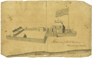
S. east view of Fort St. Tammany : N. Hayward to Major H. Burbeck
904.
Saml Wath to Abel Richardson : Wm Foster to James Foster exec ditto
905.
Sandy Hook, New Jersey
906.
Savannah and its defenses
907.
Savannah River and Savannah Sound
908.
A scetch [sic] of that part of Statten island from the Old Star [Ferry] to Deckers Ferry and the lands lying to the westd. of...
909.
Schauplatz des kriegs zwischen Engelland und seinen collonien in America nach richtigen carten gezeichnet und in diese form...
910.
The seat of action between the British and American forces or an authentic plan of Staten Island with the neighbouring...
911.
The seat of action, between the British and American forces or an authentic plan of the western part of Long Island, with the...
912.
Seat of war in the environs of Philadelphia
913.
Seconnet Passage
914.
Section of the level of the country
915.
The Seven Islands and the Bay
916.
The Shoals of Beauport; The River St. Lawrence from the Basin of Quebec to the Falls of Richeu
917.
Siège d'York 1781 : carte des environs d'York en Virginie avec les attaques et la position des armées Françoise et Américaine...
918.
Siege of Charleston, South Carolina 1780
919.
Siege of Charlestown 1780
920.
Siege of Yorktown
‹ Prev
Next ›
1
2
…
42
43
44
45
46
47
48
49
50
51
52


![A scetch [sic] of that part of Statten island from the Old Star [Ferry] to Deckers Ferry and the lands lying to the westd. of the road leading from Deckers Ferry to the Old Star made from a view of the same by Thomas Millidge major of the 5th battn. of N: J V](https://bpldcassets.blob.core.windows.net/derivatives/metadata/commonwealth-oai:1831hj84z/image_thumbnail_300.jpg)