Toggle navigation
LMEC Home
Exhibitions
Georeferencing
Tools for Teachers
Collections
My Favorites
Sign Up / Log In
Search
Search the map portal
Map Collection
Map Collection
Map Sets
Search
Search
Search for
Search In
All Fields
Creator
Title
Subject
Place
Search All Digital Collections
Advanced Search
938 Results
My Search
Start Over
More Like
commonwealth-oai:k356f1598
Remove constraint More Like: commonwealth-oai:k356f1598
Filter your Search
Place
North and Central America
912
United States
626
Canada
231
New York
193
Quebec
113
Pennsylvania
60
New Jersey
54
Nova Scotia
48
more
Place
»
Topic
United States--History--Revolution, 1775-1783--Maps
305
United States--History--French and Indian War, 1754-1763--Maps
149
Saint Lawrence River--Maps
43
Newport (R.I.)--Maps
27
New York (State)--Maps
25
Hudson River (N.Y. and N.J.)--Maps
21
Québec (Québec)--Maps
21
Louisbourg (N.S.)--Maps
20
more
Topic
»
Date
Date range begin
–
Date range end
Current results range from
1700
to
1921
View distribution
Creator
Rocque, Mary Ann
29
Bellin, Jacques Nicolas, 1703-1772
25
Holland, Samuel, 1728-1801
25
Jefferys, Thomas, -1771
25
Montrésor, John, 1736-1799
25
Clinton, Henry, Sir, 1738?-1795
19
Robert Sayer and John Bennett (Firm)
15
Hills, John, active 1777-1819
13
more
Creator
»
Format
Maps/Atlases
922
Drawings/Illustrations
11
Documents
5
Prints
1
Georeferenced
No
938
Collection
American Revolutionary War-Era Maps
916
William L. Clements Library Collection
909
Norman B. Leventhal Map & Education Center Collection
22
Library and Archives Canada Collection
4
MacLean Collection Map Library
3
Available to use
No known restrictions
22
Search Constraints
Sort by relevance
relevance
title
date (asc)
date (desc)
Number of results to display per page
20 per page
10
per page
20
per page
50
per page
100
per page
View results as:
grid view
map view
Search Results
1.
A map of the lakes & Hudsons Bay
2.
A map of the lakes & Hudsons Bay
3.
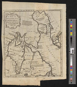
A map of Hudsons Bay and parts adjacent from the latest surveys and best authorities
4.
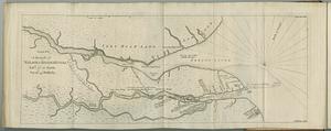
Sketch of the seven dangerous rappids with their true channel : also the appearance the river makes at those places between...
5.
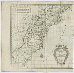
Carte generale des treize Etats-Unis & independants de l'Amerique Septentrional
6.
A draught of Nelson & Hayes's Rivers latd. 57°. 10'. north, var. 16°. 45'. westerly
7.
Government map of part of the Huron and Ottawa Territory, Ontario
8.
Map of Ontario and Quebec showing location and capacity of flour mills and elevators
9.
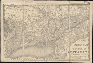
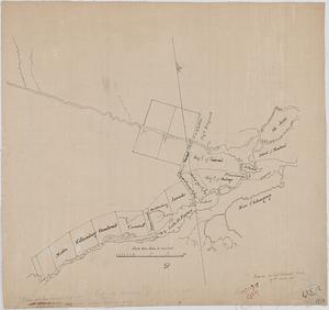
Map of the eastern part of the Province of Ontario
10.
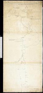
Map of the northern part of the state of New York
11.
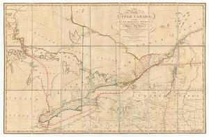
A map of the province of Upper Canada, describing all the new settlements, townships, & cc. with the countries adjacent, from...
12.
A map of the province of upper Canada, describing all the new settlements, townships, &c. with the countries adjacent, from...
13.
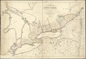
Map of the province of Upper Canada shewing the organized part thereof and the adjacent county
14.
A map of Upper and Lower Canada : with part of the United States adjoining, comprising the present seat of war
15.
Proposed division line for Upper and Lower Canada
16.
Scarborough's map of Ontario : with an index of all cities, villages, post-offices and railway stations and population...
17.
Sketch of a route from Yorktown on Lake Ontario to Penatangasheen on Lake Huron - Upper Canada
18.
Sketch of a route from Yorktown on Lake Ontario to Penatangasheen on Lake Huron - Upper Canada
19.
Topographical plan of the north shore of Lake Huron shewing recent surveys
20.
Carte des découvertes qui ont été faites dans la partie occidentale du Canada sur les mémoires de Mr de la Varanderie [Vérendrye]
‹ Prev
Next ›
1
2
3
4
5
…
46
47


![Carte des découvertes qui ont été faites dans la partie occidentale du Canada sur les mémoires de Mr de la Varanderie [Vérendrye]](https://bpldcassets.blob.core.windows.net/derivatives/images/commonwealth:wp98ck41z/image_thumbnail_300.jpg)