Toggle navigation
LMEC Home
Exhibitions
Georeferencing
Tools for Teachers
Collections
My Favorites
Sign Up / Log In
Search
Search the map portal
Map Collection
Map Collection
Map Sets
Search
Search
Search for
Search In
All Fields
Creator
Title
Subject
Place
Search All Digital Collections
Advanced Search
937 Results
My Search
Start Over
More Like
commonwealth-oai:bv73gz08m
Remove constraint More Like: commonwealth-oai:bv73gz08m
Filter your Search
Place
North and Central America
911
United States
651
Canada
205
New York
196
Quebec
111
Pennsylvania
65
New Jersey
57
Nova Scotia
48
more
Place
»
Topic
United States--History--Revolution, 1775-1783--Maps
305
United States--History--French and Indian War, 1754-1763--Maps
149
Saint Lawrence River--Maps
43
New York (State)--Maps
29
Middle Atlantic States--Maps
27
Newport (R.I.)--Maps
27
Pennsylvania--Maps
24
Hudson River (N.Y. and N.J.)--Maps
21
more
Topic
»
Date
Date range begin
–
Date range end
Current results range from
1700
to
1969
View distribution
Creator
Rocque, Mary Ann
29
Holland, Samuel, 1728-1801
25
Jefferys, Thomas, -1771
25
Montrésor, John, 1736-1799
25
Bellin, Jacques Nicolas, 1703-1772
24
Clinton, Henry, Sir, 1738?-1795
19
Robert Sayer and John Bennett (Firm)
16
Hills, John, active 1777-1819
13
more
Creator
»
Format
Maps/Atlases
921
Drawings/Illustrations
11
Documents
5
Manuscripts
1
Prints
1
Georeferenced
Yes
5
No
932
Collection
American Revolutionary War-Era Maps
916
William L. Clements Library Collection
909
Norman B. Leventhal Map & Education Center Collection
21
MacLean Collection Map Library
6
New York Public Library Collection
1
Available to use
No known restrictions
21
Creative Commons license
1
Search Constraints
Sort by relevance
relevance
title
date (asc)
date (desc)
Number of results to display per page
20 per page
10
per page
20
per page
50
per page
100
per page
View results as:
grid view
map view
Search Results
461.
Part of the Richelieu River showing Fort de St. Ieant
462.
Part of the Richelieu River showing Isle aux Noix
463.
Part of the southwestern shore of Long Island
464.
Part of the state of Pennsylvania : to the honble. Josiah Harmar esqr. brigdr. genl. & lt. col. commdg. 1st U.S. Regt.
465.
A particular discription of that part of the coast of Connecticut extending from Byram River to Stratford Point : these...
466.
Partie de l'état de Rhode-Island et position des armées Américaine et Britannique au siege de Newport et à l'affaire du 29 Août...
467.
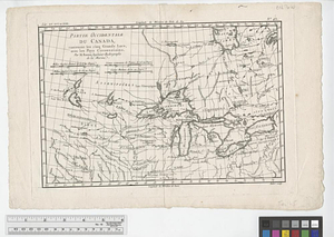
Partie occidentale de la Nouvelle France ou Canada
468.
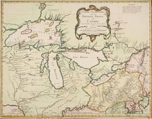
Partie occidentale du Canada contenant les cinq Grands Lacs, avec les pays circonvoisons
469.
Partie occidentale du Canada contenant les cinqs grands lac [sic], avec les pays criconvoisins [sic]
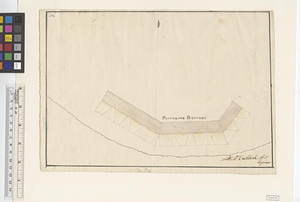
470.
Patterson Battery
471.
Paulus Hook
472.
Paulus Hook and Bergen : surveyed and draughted from the 22d. to 29th June 1781
473.
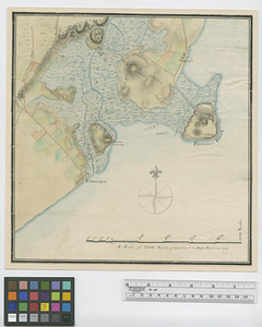
Penobscot Bay
474.
Pensacola
475.
[Perspecti]ve view of the environs of [Bosto]n from Beacon Hill shewing the rebels [works?] & encampmentss, July 22d, 1775
476.
Philadelphia : dedicated to his excellency Sir Henry Clinton K.B. general and commander in chief of his majesty's forces,...
477.
Philadelphia
478.
Phillipse Manor
479.
A plan & section of a survey taken April 20, 1801 on a new prepared course for the Middlesex Canal, from the south end of...
480.
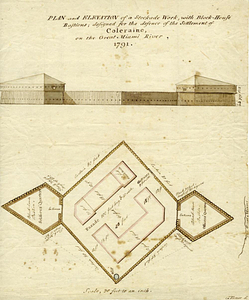
Plan and elevation of a stockade work, with block-house bastions; designed for the defence of the settlement of Coleraine, on...
‹ Prev
Next ›
1
2
…
20
21
22
23
24
25
26
27
28
…
46
47


![Partie occidentale du Canada contenant les cinqs grands lac [sic], avec les pays criconvoisins [sic]](https://bpldcassets.blob.core.windows.net/derivatives/metadata/commonwealth-oai:tx31vg299/image_thumbnail_300.jpg)

![[Perspecti]ve view of the environs of [Bosto]n from Beacon Hill shewing the rebels [works?] & encampmentss, July 22d, 1775](https://bpldcassets.blob.core.windows.net/derivatives/metadata/commonwealth-oai:6d573t29z/image_thumbnail_300.jpg)