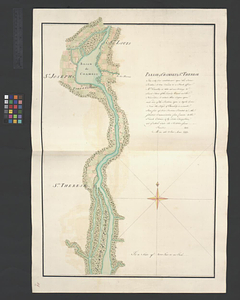
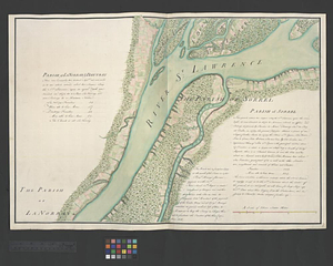
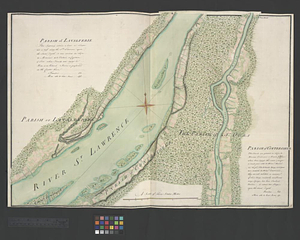
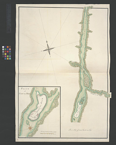
Part of the Richelieu River showing Isle aux Noix
This map is also available in American Revolutionary Geographies Online (ARGO), a collections portal especially built for material relating to the American Revolutionary War Era. Visit ARGO to learn more about this item and explore the historical geography of North America in the late eighteenth century.
Item Information
- Title:
- Part of the Richelieu River showing Isle aux Noix
- Title (alt.):
-
Plan of Isle aux Noix
- Date:
-
[ca. 1761]
- Format:
-
Maps/Atlases
- Genre:
-
Manuscript maps
- Location:
- William L. Clements Library
- Collection (local):
-
William L. Clements Library Collection
- Subjects:
-
Noix Island (Le Haut-Richelieu, Québec)--Maps
Richelieu River (N.Y. and Vt-Québec)--Maps
United States--History--French and Indian War, 1754-1763--Maps
- Places:
-
CanadaQuebec (province)Île aux Noix (island)
Richelieu River
- Extent:
- 1 ms. map : col. ; 72.7 x 51.8 cm.
- Terms of Use:
-
The University of Michigan Library provides access to these materials for educational and research purposes. These materials may be under copyright. If you decide to use any of these materials, you are responsible for making your own legal assessment and securing any necessary permission. If you have questions about the collection, please contact the William L. Clements Library.
Contact host institution for more information.
- Scale:
-
Scale 1:24,000. Scale of inset 1:9,600.
- Language:
-
English
- Catalog Record:
-
Catalog record
- Notes:
-
Finished, colored, topographical map.
Map includes an inset map that corresponds with an inset map on key map sheet 16.
Map is sheet 31 of the Murray Atlas of Canada and sheet 15 of its series.
- Identifier:
-
187
- Barcode:
-
B3522033