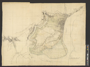
Philadelphia
This map is also available in American Revolutionary Geographies Online (ARGO), a collections portal especially built for material relating to the American Revolutionary War Era. Visit ARGO to learn more about this item and explore the historical geography of North America in the late eighteenth century.
Item Information
- Title:
- Philadelphia
- Date:
-
[ca. 1777]
- Format:
-
Maps/Atlases
- Genre:
-
Manuscript maps
- Location:
- William L. Clements Library
- Collection (local):
-
William L. Clements Library Collection
- Subjects:
-
Philadelphia (Pa.)--Maps
United States--History--Revolution, 1775-1783--Maps
- Places:
-
PennsylvaniaPhiladelphia (county)Philadelphia
- Extent:
- 1 ms. map : col. ; 71 x 90.5 cm.
- Terms of Use:
-
The University of Michigan Library provides access to these materials for educational and research purposes. These materials may be under copyright. If you decide to use any of these materials, you are responsible for making your own legal assessment and securing any necessary permission. If you have questions about the collection, please contact the William L. Clements Library.
Contact host institution for more information.
- Scale:
-
Scale 1:16,000.
- Language:
-
English
- Catalog Record:
-
Catalog record
- Notes:
-
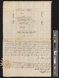
Finished, colored, topographical map of the city and its environs showing the area between the Delaware and Schuylkill rivers as far south as League Island.
Steets and roads are clearly marked.
Survey probably completed during the British occupation of the city in 1777-1778.
In pencil in a later hand at lower right: Philadelphia.
Clinton Maps 251.
- Identifier:
-
8372
- Barcode:
-
B2664948