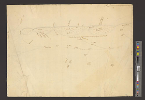
Part of the southwestern shore of Long Island
This map is also available in American Revolutionary Geographies Online (ARGO), a collections portal especially built for material relating to the American Revolutionary War Era. Visit ARGO to learn more about this item and explore the historical geography of North America in the late eighteenth century.
Item Information
- Title:
- Part of the southwestern shore of Long Island
- Date:
-
[1770–1779]
- Format:
-
Maps/Atlases
- Genre:
-
Manuscript maps
- Location:
- William L. Clements Library
- Collection (local):
-
William L. Clements Library Collection
- Subjects:
-
Long Island (N.Y.)--Maps
- Places:
-
New YorkLong Island (island)
- Extent:
- 1 ms. map ; 40 x 52 cm.
- Terms of Use:
-
The University of Michigan Library provides access to these materials for educational and research purposes. These materials may be under copyright. If you decide to use any of these materials, you are responsible for making your own legal assessment and securing any necessary permission. If you have questions about the collection, please contact the William L. Clements Library.
Contact host institution for more information.
- Scale:
-
Scale indeterminate.
- Language:
-
English
- Catalog Record:
-
Catalog record
- Notes:
-
Pencil and pen and ink sketch of part of the south shore of Long Island, primarily in Queens and Nassau counties giving notations of property owners along the shore and relative positions of some inland towns.
Clinton Map 123.
- Notes (date):
-
This date is inferred.
- Identifier:
-
848
- Barcode:
-
B2846392


