Toggle navigation
LMEC Home
Exhibitions
Georeferencing
Tools for Teachers
Collections
My Favorites
Sign Up / Log In
Search
Search the map portal
Map Collection
Map Collection
Map Sets
Search
Search
Search for
Search In
All Fields
Creator
Title
Subject
Place
Search All Digital Collections
Advanced Search
1000 Results
My Search
Start Over
More Like
commonwealth-oai:b2777s68s
Remove constraint More Like: commonwealth-oai:b2777s68s
Filter your Search
Place
North and Central America
972
United States
710
Canada
206
New York
201
Quebec
112
Pennsylvania
91
New Jersey
80
Massachusetts
50
more
Place
»
Topic
United States--History--Revolution, 1775-1783--Maps
330
United States--History--French and Indian War, 1754-1763--Maps
149
Pennsylvania--Maps
50
Saint Lawrence River--Maps
43
New Jersey--Maps
40
New York (State)--Maps
34
Newport (R.I.)--Maps
27
Maryland--Maps
25
more
Topic
»
Date
Date range begin
–
Date range end
Current results range from
1700
to
1921
View distribution
Creator
Rocque, Mary Ann
29
Holland, Samuel, 1728-1801
26
Bellin, Jacques Nicolas, 1703-1772
25
Jefferys, Thomas, -1771
25
Montrésor, John, 1736-1799
25
Clinton, Henry, Sir, 1738?-1795
19
Robert Sayer and John Bennett (Firm)
16
Kitchin, Thomas, 1719-1784
13
more
Creator
»
Format
Maps/Atlases
984
Drawings/Illustrations
11
Documents
5
Manuscripts
5
Prints
1
Georeferenced
Yes
27
No
973
Collection
American Revolutionary War-Era Maps
945
William L. Clements Library Collection
909
Norman B. Leventhal Map & Education Center Collection
60
Maps from AAS
15
MacLean Collection Map Library
6
Boston and New England Maps
5
Urban Maps
5
Newberry Library Collection
3
more
Collection
»
Available to use
No known restrictions
62
Creative Commons license
5
Search Constraints
Sort by relevance
relevance
title
date (asc)
date (desc)
Number of results to display per page
20 per page
10
per page
20
per page
50
per page
100
per page
View results as:
grid view
map view
Search Results
241.
Plan of Washingtons position
242.
Plan of West Point, Virginia
243.
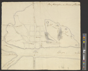
Plan of Wilmington in the province of Nth: Carolina
244.
Plan von dem schiff-bauplatz bei Hallifax in Neuscholland
245.
Plan von Halifax in Nord-America
246.
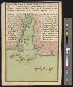
Plano del lago o rio de Movila situada su pta. en lt. N 30.10 en logd. 284.40 ms. Sacado se a consido consus nombres costas...
247.
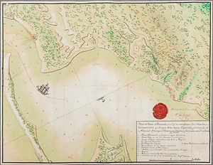
Plano del puerto de Panzacola en el qe. se manifiestan las marchas, campamentos y ataque de las tropas Espanolas : al mando del...
248.
Portsmouth
249.
Portsmouth and Norfolk
250.
Position of the troops under Earl Cornwallis on the 28 and 29th September 1781; when the enemy first appeared
251.
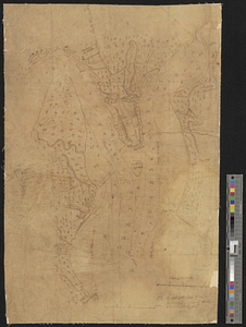
Positions of the British troops between the Hudson River and the Bronx River at Valentine's Hill
252.
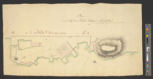
Proposed fortifications for Savannah
253.
Proposed redoubt at Canoe Place
254.
Providence and Newport
255.
The Rahway River valley, ca. 1780
256.
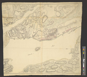
Reconnoissance des ouvrages de Ouët Point : etablis pour couvrir et assurer la communication des états du nord avec ceux du...
257.
Region between Westchester Creek and the Bronx River
258.
A rough draught of New Haven fort
259.
Sandy Hook, New Jersey
260.
Savannah and its defenses
‹ Prev
Next ›
1
2
…
9
10
11
12
13
14
15
16
17
…
49
50