Toggle navigation
LMEC Home
Exhibitions
Georeferencing
Tools for Teachers
Collections
My Favorites
Sign Up / Log In
Search
Search the map portal
Map Collection
Map Collection
Map Sets
Search
Search
Search for
Search In
All Fields
Creator
Title
Subject
Place
Search All Digital Collections
Advanced Search
1138 Results
My Search
Start Over
More Like
commonwealth-oai:7w62k649j
Remove constraint More Like: commonwealth-oai:7w62k649j
Filter your Search
Place
North and Central America
1,112
United States
838
Massachusetts
268
Canada
206
New York
195
Quebec
111
Suffolk (county)
67
Rhode Island
64
more
Place
»
Topic
United States--History--Revolution, 1775-1783--Maps
306
Massachusetts--Maps
235
United States--History--French and Indian War, 1754-1763--Maps
149
Boston (Mass.)--Maps
56
Saint Lawrence River--Maps
43
Rhode Island--Maps
34
Railroads--Massachusetts--Maps
31
Newport (R.I.)--Maps
27
more
Topic
»
Date
Date range begin
–
Date range end
Current results range from
1700
to
2020
View distribution
Creator
Rocque, Mary Ann
29
Holland, Samuel, 1728-1801
25
Montrésor, John, 1736-1799
25
Bellin, Jacques Nicolas, 1703-1772
24
Jefferys, Thomas, -1771
24
MassGIS (Office : Mass.)
20
Clinton, Henry, Sir, 1738?-1795
19
Geo. H. Walker & Co
15
more
Creator
»
Format
Maps/Atlases
1,120
Drawings/Illustrations
11
Documents
5
Manuscripts
3
Prints
2
Ephemera
1
Georeferenced
Yes
65
No
1,073
Collection
American Revolutionary War-Era Maps
921
William L. Clements Library Collection
909
Norman B. Leventhal Map & Education Center Collection
206
Boston and New England Maps
170
Applied Geographics, Inc. Records
20
David Judkins Weaver Papers
18
Urban Maps
11
Sidney R. Knafel Map Collection at Phillips Academy
8
more
Collection
»
Available to use
No known restrictions
198
Creative Commons license
12
Search Constraints
Sort by relevance
relevance
title
date (asc)
date (desc)
Number of results to display per page
20 per page
10
per page
20
per page
50
per page
100
per page
View results as:
grid view
map view
Search Results
741.
Plan of a city block in Wilmington, Delaware : for Mr Fredrick Wirt 1772
742.
Plan of a fortification who seems necessary on Shutters Folly Island to second the firing of Fort Johnson on any vessel that...
743.
A plan of a rout from Fort Pownall on the river Penobscot in New England to Quebec and from Quebec to Fort Pownall : taken by...
744.
Plan of a settlement call'd Dunlaps Station
745.
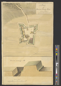
Plan of an intrench'd guard house at the north end of Howlands Neck, June 1777
746.
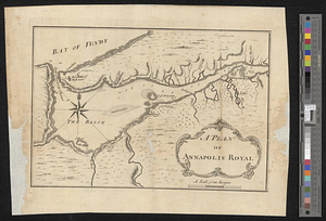
A plan of Annapolis Royal
747.
A plan of Black River on the Mosquito shore : surveyed in 1779
748.
A plan of Boston in New England with its environs, including Milton, Dorchester, Roxbury, Brooklin, Cambridge, Medford,...
749.
A plan of Bristol Ferry fort
750.
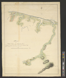
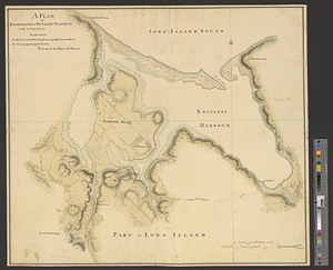
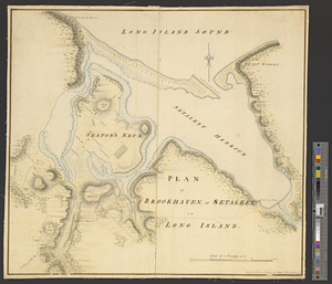
A plan of Brookhaven or Setalket Harbour with its environs
751.
Plan of Brookhaven, or Setalket on Long Island
752.
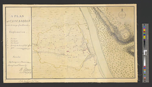
A plan of Cascasquias with the design of an enceinte
753.
Plan of Charleston and its defenses 1780
754.
Plan of Charlestown 1781
755.
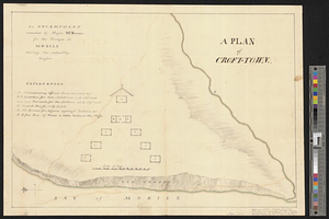
A plan of Croft-town : an encampment intended by Major McKenzie for the troops at Mobile during the unhealthy season
756.
Plan of Dean Danl Greens farm in Reading
757.
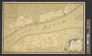
Plan of Detroit with its environs
758.
Plan of Elizbth Town
759.
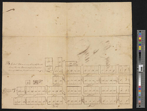
Plan of fifty different tracts of land, (of 1000 acres each) containing in the whole 50,000 acres, situate on the waters of...
760.
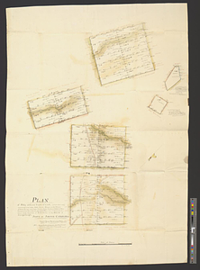
Plan of Fort [Brewerton] at the west end of Onnide Lake
‹ Prev
Next ›
1
2
…
34
35
36
37
38
39
40
41
42
…
56
57


![Plan of Fort [Brewerton] at the west end of Onnide Lake](https://bpldcassets.blob.core.windows.net/derivatives/metadata/commonwealth-oai:639615613/image_thumbnail_300.jpg)