Toggle navigation
LMEC Home
Exhibitions
Georeferencing
Tools for Teachers
Collections
My Favorites
Sign Up / Log In
Search
Search the map portal
Map Collection
Map Collection
Map Sets
Search
Search
Search for
Search In
All Fields
Creator
Title
Subject
Place
Search All Digital Collections
Advanced Search
971 Results
My Search
Start Over
More Like
commonwealth-oai:7h14fn780
Remove constraint More Like: commonwealth-oai:7h14fn780
Filter your Search
Place
North and Central America
945
United States
681
New York
251
Canada
208
Quebec
112
Pennsylvania
69
New Jersey
62
Nova Scotia
48
more
Place
»
Topic
United States--History--Revolution, 1775-1783--Maps
305
United States--History--French and Indian War, 1754-1763--Maps
150
New York (State)--Maps
85
Saint Lawrence River--Maps
43
Newport (R.I.)--Maps
27
Pennsylvania--Maps
27
Hudson River (N.Y. and N.J.)--Maps
23
New England--Maps
22
more
Topic
»
Date
Date range begin
–
Date range end
Current results range from
1700
to
1976
View distribution
Creator
Rocque, Mary Ann
29
Holland, Samuel, 1728-1801
26
Bellin, Jacques Nicolas, 1703-1772
25
Montrésor, John, 1736-1799
25
Jefferys, Thomas, -1771
24
Clinton, Henry, Sir, 1738?-1795
19
Robert Sayer and John Bennett (Firm)
15
Hills, John, active 1777-1819
13
more
Creator
»
Format
Maps/Atlases
955
Drawings/Illustrations
11
Documents
5
Manuscripts
2
Prints
1
Georeferenced
Yes
7
No
964
Collection
American Revolutionary War-Era Maps
925
William L. Clements Library Collection
909
Norman B. Leventhal Map & Education Center Collection
47
Boston and New England Maps
13
American Antiquarian Society Collection
9
MacLean Collection Map Library
4
Massachusetts Historical Society Map Collection
1
New-York Historical Society Collection
1
Available to use
No known restrictions
48
Creative Commons license
1
Search Constraints
Sort by relevance
relevance
title
date (asc)
date (desc)
Number of results to display per page
20 per page
10
per page
20
per page
50
per page
100
per page
View results as:
grid view
map view
Search Results
221.
A draught of the barr off Mobile & Dauphine Island
222.
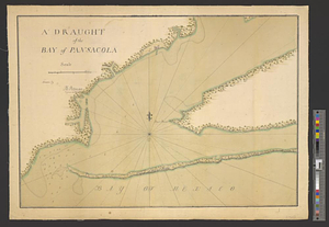
A draught of the bay of Pansacola
223.
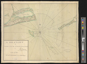
A draught of the harbor & river of Piscataqua with the Island's of Shoal's
224.
A draught of the harbor & river of Piscataqua with the Island's of Shoal's
225.
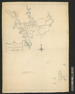
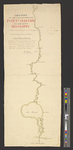
Draught of the passage from Lake Pontchartrin to the river Missisippi
226.
Draught of the river Delaware from Chester to Philadelphia
227.
A draught of the river Missisippi. From the Balise to Fort Cavendish : taken in the months of June, July, August, September,...
228.
Draught of the River Pittquioyack in the Bay of Fundy 1758
229.
Draught of the river St. Lawrence from Lake Ontario to Montreal
230.
A draught of the towns of Boston & Charles Town & the circumjacent country, shewing the works thrown up by the kings troops, &...
231.
A draught of the upper Creek nation, taken in May 1757
232.
Draught of the watering place & redouts constructed to defend it, 15th: July 1776
233.
The Dutch islands of St. Eustatia, Saba, and St. Martins; the French island of St. Bartholomew; the English islands of St....
234.
An east view of Fort [Franklin] on French Creek
235.
Eastern section of the United States
236.
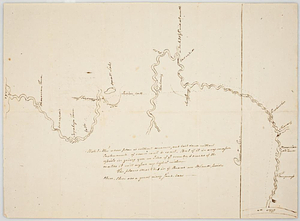
Ensign Nathan Mc:Dowell's draft of the water of big Beaver &c to Lake Erie
237.
Etats Unis de l'Amerique
238.
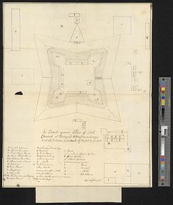
An exact ground plan of Fort Edward at Pesaquid taken from a survey and laid down by a scale of 60 feet to one inch
239.
An exact map of Nova Scotia, Newfoundland, gulf and river St. Laurence, and coast of Labrador from the latest observations 1777
240.
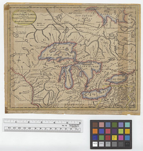
An exact map of the five Great Lakes, with part of Pensilvania, New York, Canada and Hudsons Bay territories from the best surveys
‹ Prev
Next ›
1
2
…
8
9
10
11
12
13
14
15
16
…
48
49


![An east view of Fort [Franklin] on French Creek](https://bpldcassets.blob.core.windows.net/derivatives/metadata/commonwealth-oai:dj5314216/image_thumbnail_300.jpg)