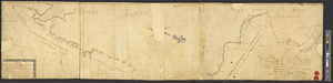
A draught of the upper Creek nation, taken in May 1757

This map is also available in American Revolutionary Geographies Online (ARGO), a collections portal especially built for material relating to the American Revolutionary War Era. Visit ARGO to learn more about this item and explore the historical geography of North America in the late eighteenth century.
Item Information
- Title:
- A draught of the upper Creek nation, taken in May 1757
- Contributor:
- Bonar, William
- Contributor:
- Romans, Bernard, 1741?-approximately 1784
- Date:
-
1757
- Format:
-
Maps/Atlases
- Genre:
-
Manuscript maps
- Location:
- William L. Clements Library
- Collection (local):
-
William L. Clements Library Collection
- Subjects:
-
Creek Indians--Maps
Alabama--Maps
Coosa River (Ga. and Ala.)--Maps
Tallapoosa River (Ga. and Ala.)--Maps
- Places:
-
Alabama
Coosa River
Tallapoosa River
- Extent:
- 1 ms. map ; 30.4 x 35 cm
- Terms of Use:
-
The University of Michigan Library provides access to these materials for educational and research purposes. These materials may be under copyright. If you decide to use any of these materials, you are responsible for making your own legal assessment and securing any necessary permission. If you have questions about the collection, please contact the William L. Clements Library.
Contact host institution for more information.
- Scale:
-
Scale indeterminable.
- Language:
-
English
- Catalog Record:
-
Catalog record
- Notes:
-
Shows upper Creek villages near Fort Toulouse, particularly along the Coosa and Tallapoosa Rivers.
Gives number of fighting men and towns.
Similar to "A draught of the Creek nation by William Bonar, May 1757" in the British Colonial Office.
Map possibly drawn by Bernard Romans.
- Identifier:
-
5528
- Barcode:
-
B1936539