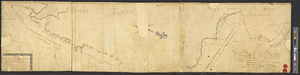
A map of the Indian nations in the southern department, 1766

This map is also available in American Revolutionary Geographies Online (ARGO), a collections portal especially built for material relating to the American Revolutionary War Era. Visit ARGO to learn more about this item and explore the historical geography of North America in the late eighteenth century.
Item Information
- Title:
- A map of the Indian nations in the southern department, 1766
- Creator:
- De Brahm, John Gerar William, 1717-approximately 1799
- Date:
-
1766
- Format:
-
Maps/Atlases
- Genre:
-
Manuscript maps
- Location:
- William L. Clements Library
- Collection (local):
-
William L. Clements Library Collection
- Subjects:
-
Creek Indians--Maps
Cherokee Indians--Maps
Chickasaw Indians--Maps
Choctaw Indians--Maps
Delaware Indians--Maps
Southern States--Maps
- Places:
-
Southern United States (area)
- Extent:
- 1 ms. map ; 46.5 x 58 cm.
- Terms of Use:
-
The University of Michigan Library provides access to these materials for educational and research purposes. These materials may be under copyright. If you decide to use any of these materials, you are responsible for making your own legal assessment and securing any necessary permission. If you have questions about the collection, please contact the William L. Clements Library.
Contact host institution for more information.
- Scale:
-
Scale 1:1,500,000.
- Language:
-
English
- Catalog Record:
-
Catalog record
- Notes:
-
Finished, pen and ink, topographical map showing many of the villages of the Chickasaw, Choctaw, Creek, and Cherokee Indians.
Also shows principal forts and towns of the area between the Mississippi and the east coast from Virginia to the south.
- Identifier:
-
562
- Barcode:
-
B2640388
![A map of West Florida and part of Et: Florida, Georgia part of So: Carolina i[n]cluding [torn] & Chactaw, Chickasaw & Creek nations with [torn] [r]oad [torn] Pensacola through ye: Creek nation to Augusitus & Charlestown](https://bpldcassets.blob.core.windows.net/derivatives/metadata/commonwealth-oai:v98001375/image_thumbnail_300.jpg)