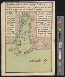
A draught of the barr off Mobile & Dauphine Island
This map is also available in American Revolutionary Geographies Online (ARGO), a collections portal especially built for material relating to the American Revolutionary War Era. Visit ARGO to learn more about this item and explore the historical geography of North America in the late eighteenth century.
Item Information
- Title:
- A draught of the barr off Mobile & Dauphine Island
- Creator:
- Pittman, Philip, active 1760-1770
- Name on Item:
-
by Ph: Pittman lieutt 15th Regt & engineer at Mobille
- Date:
-
[1765]
- Format:
-
Maps/Atlases
- Genre:
-
Manuscript maps
- Location:
- William L. Clements Library
- Collection (local):
-
William L. Clements Library Collection
- Subjects:
-
Mobile Bay (Ala.)--Maps
- Places:
-
AlabamaMobile Bay
- Extent:
- 1 ms. map : col. ; 29.7 x 39 cm
- Terms of Use:
-
The University of Michigan Library provides access to these materials for educational and research purposes. These materials may be under copyright. If you decide to use any of these materials, you are responsible for making your own legal assessment and securing any necessary permission. If you have questions about the collection, please contact the William L. Clements Library.
Contact host institution for more information.
- Scale:
-
Scale 1:63,360.
- Language:
-
English
- Catalog Record:
-
Catalog record
- Notes:
-
Finished, colored, topographical map showing Dauphine and Pelican Islands and part of Mobile Point with soundings for the bar.
Enclosed in Pittman to Gage, March 27, 1765.
- Notes (date):
-
This date is inferred.
- Identifier:
-
5566
- Barcode:
-
B1938907