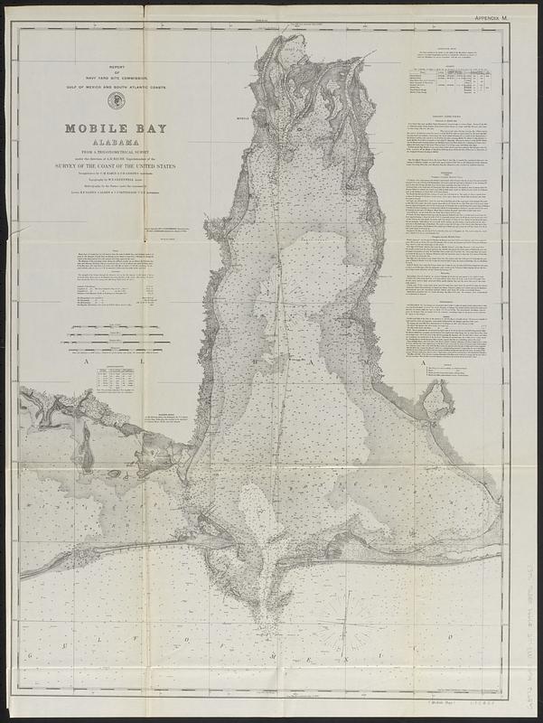
Mobile Bay, Alabama
Item Information
- Title:
- Mobile Bay, Alabama
- Issuing body:
- United States. Commission on Navy-Yards
- Cartographer:
- United States Coast Survey
- Issuing body:
- United States. Navy Department
- Name on Item:
-
from a trigonometrical survey under the direction of A.D. Bache, Superintendent of the Survey of the Coast of the United States ; triangulation by C.M. Eakin & F.H. Gerdes, assistants ; topography by W.E. Greenwell, assistant ; hydrography by the parties under the command of Lieuts. B.F. Sands, J. Alden, & C.P. Patterson U.S.N., assistants
- Date:
-
[ca. 1900]
- Format:
-
Maps/Atlases
- Genre:
-
Nautical charts
- Location:
-
Boston Public Library
Norman B. Leventhal Map & Education Center - Collection (local):
-
Norman B. Leventhal Map & Education Center Collection
- Subjects:
-
Mobile Bay (Ala.)--Maps
Navigation--Alabama--Mobile Bay
Shipyards--Alabama--Mobile Bay--Planning
- Places:
-
AlabamaMobile Bay
- Extent:
- 1 map ; 63 x 46 cm
- Terms of Use:
-
No known copyright restrictions.
No known restrictions on use.
- Publisher:
-
[Washington] :
[Government Printing Office]
- Scale:
-
Scale approximately 1:123,000
- Language:
-
English
- Notes:
-
Depths shown by soundings and gradients.
Prime meridians: Fort Morgan and Greenwich.
Shows potential sites for a navy yard near Mobile.
Includes tables and text about navigation information.
"June 1888 dredged channel."
"Appendix M."
"Plate no. 1158."
In lower right corner: (Mobile Bay) U.S.C. & G.S.
Originally appeared in a report from the Navy Yard Site Commission issued approximately 1889. Detached from a report from the Navy Department issued approximately 1900.
- Identifier:
-
06_01_018419
- Call #:
-
G3972.M6P5 1888 .U5
- Barcode:
-
39999085967253