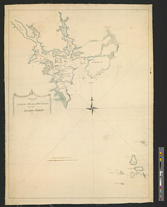
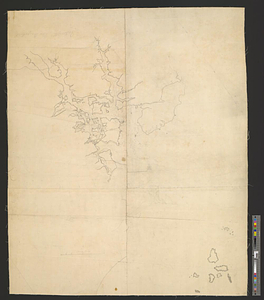
A draught of the harbor & river of Piscataqua with the Island's of Shoal's
This map is also available in American Revolutionary Geographies Online (ARGO), a collections portal especially built for material relating to the American Revolutionary War Era. Visit ARGO to learn more about this item and explore the historical geography of North America in the late eighteenth century.
Item Information
- Title:
- A draught of the harbor & river of Piscataqua with the Island's of Shoal's
- Creator:
- Mist, Charles
- Date:
-
[1770–1779]
- Format:
-
Maps/Atlases
- Genre:
-
Manuscript maps
- Location:
- William L. Clements Library
- Collection (local):
-
William L. Clements Library Collection
- Subjects:
-
Piscataqua River (N.H. and Me.)--Maps
- Places:
-
Piscataqua River
- Extent:
- 1 ms. map ; 83.7 x 74 cm
- Terms of Use:
-
The University of Michigan Library provides access to these materials for educational and research purposes. These materials may be under copyright. If you decide to use any of these materials, you are responsible for making your own legal assessment and securing any necessary permission. If you have questions about the collection, please contact the William L. Clements Library.
Contact host institution for more information.
- Scale:
-
Scale 1:24,000.
- Language:
-
English
- Catalog Record:
-
Catalog record
- Notes:
-
Unfinished outline pen and ink map with some place names and soundings recorded in pencil.
Map essentially the same as Clinton Map 37 of same title.
Clinton Maps 38.
- Notes (date):
-
This date is inferred.
- Identifier:
-
8270
- Barcode:
-
B1937572