Toggle navigation
LMEC Home
Exhibitions
Georeferencing
Tools for Teachers
Collections
My Favorites
Sign Up / Log In
Search
Search the map portal
Map Collection
Map Collection
Map Sets
Search
Search
Search for
Search In
All Fields
Creator
Title
Subject
Place
Search All Digital Collections
Advanced Search
1014 Results
My Search
Start Over
More Like
commonwealth-oai:3r078t62x
Remove constraint More Like: commonwealth-oai:3r078t62x
Filter your Search
Place
North and Central America
988
United States
726
Canada
206
New York
201
Quebec
112
Pennsylvania
90
New Jersey
79
Virginia
73
more
Place
»
Topic
United States--History--Revolution, 1775-1783--Maps
308
United States--History--French and Indian War, 1754-1763--Maps
149
Pennsylvania--Maps
50
Virginia--Maps
47
Saint Lawrence River--Maps
43
New Jersey--Maps
40
Maryland--Maps
37
New York (State)--Maps
34
more
Topic
»
Date
Date range begin
–
Date range end
Current results range from
1700
to
1988
View distribution
Creator
Rocque, Mary Ann
29
Bellin, Jacques Nicolas, 1703-1772
26
Holland, Samuel, 1728-1801
26
Montrésor, John, 1736-1799
25
Jefferys, Thomas, -1771
24
Clinton, Henry, Sir, 1738?-1795
19
Robert Sayer and John Bennett (Firm)
15
Hills, John, active 1777-1819
13
more
Creator
»
Format
Maps/Atlases
998
Drawings/Illustrations
11
Documents
5
Manuscripts
2
Prints
1
Georeferenced
Yes
39
No
975
Collection
American Revolutionary War-Era Maps
934
William L. Clements Library Collection
909
Norman B. Leventhal Map & Education Center Collection
86
Maps from AAS
13
MacLean Collection Map Library
5
Urban Maps
2
David Judkins Weaver Papers
1
New York Public Library Collection
1
Available to use
No known restrictions
86
Creative Commons license
1
Search Constraints
Sort by relevance
relevance
title
date (asc)
date (desc)
Number of results to display per page
20 per page
10
per page
20
per page
50
per page
100
per page
View results as:
grid view
map view
Search Results
21.
Delaware and Maryland
22.
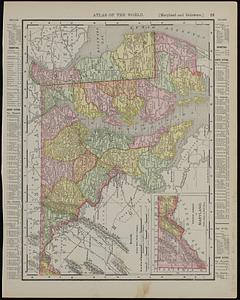
Maryland and Delaware ; Rand McNally & Co.'s map of the main portion of Baltimore
23.
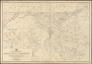
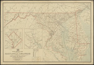
Post route map of the states of Maryland and Delaware and of the District of Columbia showing post offices with the...
24.
Post route map of the states of Maryland and Delaware and of the District of Columbia showing post offices with the...
25.
The States of Maryland and Delaware, from the latest surveys
26.
The states of Maryland and Delaware from the latest surveys, 1799
27.
Manuscript maps of U.S. states, possibly drawn by a schoolchild
28.
Carte de la Virginie, : de la Baye Chesapeack, et pays voisins. : Pour servir à l'Histoire générale des voyages. : Tirée...
29.
Map of eastern Virginia
30.
Map of eastern Virginia
31.
Map of Virginia and Maryland, constructed from the latest authorities
32.
Official map of the state of Virginia : from actual surveys by order of the executive, 1828 & 1859
33.
Seat of war in Virginia and Maryland
34.
Smith's topographical map of Virginia and Maryland
35.
Map of the country embracing the several routes examined with a view to a national road from Washington to Lake Ontario
36.
An Exact map of New England, New York, Pensylvania & New Jersey, : from the latest surveys
37.
An historical map of Pennsylvania : showing the Indian names of streams and villages, and paths of travel : the sites of old...
38.
[Map of parts of Pennsylvania, New York and New Jersey]
39.
Map of the canals and rail roads for transporting anthracite coal from the several coal fields to the city of New York
40.
Map of the State of New York with part of the states of Pennsylvania, New Jersey &c
‹ Prev
Next ›
1
2
3
4
5
6
…
50
51


![[Map of parts of Pennsylvania, New York and New Jersey]](https://bpldcassets.blob.core.windows.net/derivatives/images/commonwealth:6108vt40m/image_thumbnail_300.jpg)

