Toggle navigation
LMEC Home
Exhibitions
Georeferencing
Tools for Teachers
Collections
My Favorites
Sign Up / Log In
Search
Search the map portal
Map Collection
Map Collection
Map Sets
Search
Search
Search for
Search In
All Fields
Creator
Title
Subject
Place
Search All Digital Collections
Advanced Search
306 Results
My Search
Start Over
More Like
commonwealth:z603vw064
Remove constraint More Like: commonwealth:z603vw064
Filter your Search
Place
North and Central America
239
United States
174
New York
39
Suffolk (county)
31
Boston
29
Canada
28
North America
27
New Jersey
11
more
Place
»
Topic
North America--Maps--Early works to 1800
18
Boston (Mass.)--History--Revolution, 1775-1783--Maps--Early works to 1800
16
New York (State)--History--Revolution, 1775-1783--Maps--Early works to 1800
14
New Jersey--History--Revolution, 1775-1783--Maps--Early works to 1800
11
Vues d'optique
10
Gibraltar--History--Siege, 1779-1783--Maps--Early works to 1800
9
New York (N.Y.)--Pictorial works--Early works to 1800
9
United States--History--French and Indian War, 1754-1763--Maps--Early works to 1800
9
more
Topic
»
Date
Date range begin
–
Date range end
Current results range from
1740
to
1799
View distribution
Creator
Faden, William, 1749-1836
38
Jefferys, Thomas, -1771
29
Le Rouge, Georges-Louis
23
Des Barres, Joseph F. W. (Joseph Frederick Wallet), 1722-1824
21
Sayer, Robert, 1725-1794
19
Korn, Christoph Heinrich, 1726-1783
12
Raspe, Gabriel Nicolaus, 1712-1785
12
Simcoe, John Graves, 1752-1806
10
more
Creator
»
Format
Maps/Atlases
263
Prints
32
Manuscripts
23
Drawings/Illustrations
9
Books
2
Georeferenced
Yes
12
No
294
Collection
American Revolutionary War-Era Maps
305
Richard H. Brown Revolutionary War Map Collection at Mount Vernon
293
Norman B. Leventhal Map & Education Center Collection
7
Boston and New England Maps
5
Harvard Map Collection
2
Maritime Charts and Atlases
2
New-York Historical Society Collection
2
Urban Maps
2
more
Collection
»
Available to use
Creative Commons license
297
No known restrictions
9
Search Constraints
Sort by relevance
relevance
title
date (asc)
date (desc)
Number of results to display per page
20 per page
10
per page
20
per page
50
per page
100
per page
View results as:
grid view
map view
Search Results
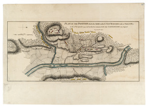
1.
Plan of the position which the army under Lt. Genl. Burgoine took at Saratoga on the 10th of September, 1777, and in which it...
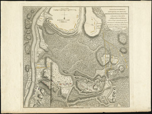
2.
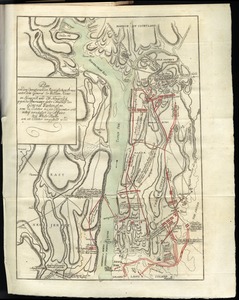
Plan of the encampment and position of the army under His Excelly. Lt. General Burgoyne at Bræmus Heights on Hudson's River...
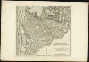
3.
Plan of the encampment and position of the army under His Excelly. Lt. General Burgoyne at Swords House on Hudson's River near...
4.
Vorstellung der diversio welche der Enll. Generel Lieutenant Clinton samt dene Generals Vaughan u. Tryon in de Ierseys im Sept....
5.
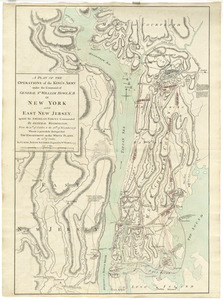
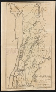
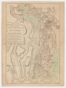
A plan of the operations of the King's army under the command of General Sr. William Howe, K.B. in New York and east New Jersey...
6.
Plan von den operationen der Koeniglichen Armee unter dem General Sir William Howe : in Neuyorck und Ost-Neujerseÿ gegen die...
7.
1st. & 2d. position of that part of the army engaged on the 19th Sept. 1777 : 3d & 4th postn. Sept. 19
8.
A map of the country in which the army under Lt. General Burgoyne acted in the campaign of 1777 : shewing the marches of the...
9.
Map of the progress of His Majesty's armies in New York, during the late campaign : illustrating the accounts published in the...
10.
A New and accurate map of the present seat of war in North America, comprehending New Jersey, Philadelphia, Pensylvania,...
11.
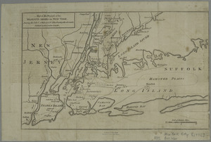
A new and accurate map of the province of New York and part of the Jerseys, New England and Canada, shewing the scenes of our...
12.
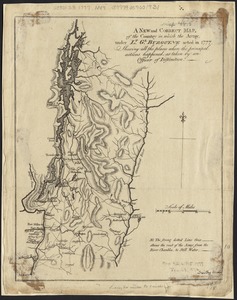
A new and correct map, of the country in which the Army, under Lt. Gl. Burgoyne acted in 1777, shewing all the places where the...
13.
A plan of New York Island, with part of Long Island, Staten Island & east New Jersey, with a particular description of the...
14.
A plan of the country from Frogspoint to Croton River shewing the positions of the American and British armies from the 12th of...
15.
A plan of the operations of the King's army : under the command of General Sr. William Howe, K.B. in New York and east New...
16.
A plan of the operations of the King's army under the command of General Sr. William Howe, K.B. in New York and east New...
17.
A plan of the operations of the King's army under the command of General Sr. William Howe, K.B. in New York and east New Jersey...
18.
Plan von den operationen der Koeniglichen Armee unter dem General Sir William Howe : in Neuyorck und Ost-Neujerseÿ gegen die...
19.
[A map of part of Pennsylvania & Maryland intended to shew, at one view, the several places proposed for opening a...
20.
Abriss der stadt Gibraltar und der darinn befindlichen festen platze, nebst dem meerbusen von Algesiras
‹ Prev
Next ›
1
2
3
4
5
…
15
16


![[A map of part of Pennsylvania & Maryland intended to shew, at one view, the several places proposed for opening a communication between the waters of the Delaware & Chesopeak Bays]](https://bpldcassets.blob.core.windows.net/derivatives/images/commonwealth:z603vt12v/image_thumbnail_300.jpg)
