Toggle navigation
LMEC Home
Exhibitions
Georeferencing
Tools for Teachers
Collections
My Favorites
Sign Up / Log In
Search
Search the map portal
Map Collection
Map Collection
Map Sets
Search
Search
Search for
Search In
All Fields
Creator
Title
Subject
Place
Search All Digital Collections
Advanced Search
337 Results
My Search
Start Over
More Like
commonwealth:z603vv407
Remove constraint More Like: commonwealth:z603vv407
Filter your Search
Place
North and Central America
270
United States
208
Suffolk (county)
72
Boston
70
Massachusetts
38
New York
32
Canada
28
North America
27
more
Place
»
Topic
Boston (Mass.)--Maps--Early works to 1800
46
Boston Harbor (Mass.)--Maps--Early works to 1800
21
Boston (Mass.)--History--Revolution, 1775-1783--Maps--Early works to 1800
19
North America--Maps--Early works to 1800
18
New England--Maps--Early works to 1800
11
United States--History--Revolution, 1775-1783--Maps--Early works to 1800
11
Vues d'optique
10
Fortification--Massachusetts--Boston--Maps--Early works to 1800
9
more
Topic
»
Date
Date range begin
–
Date range end
Current results range from
1694
to
1879
View distribution
Creator
Faden, William, 1749-1836
33
Jefferys, Thomas, -1771
30
Le Rouge, Georges-Louis
24
Des Barres, Joseph F. W. (Joseph Frederick Wallet), 1722-1824
22
Sayer, Robert, 1725-1794
19
Korn, Christoph Heinrich, 1726-1783
11
Raspe, Gabriel Nicolaus, 1712-1785
11
Simcoe, John Graves, 1752-1806
10
more
Creator
»
Format
Maps/Atlases
294
Prints
32
Manuscripts
25
Drawings/Illustrations
9
Books
2
Georeferenced
Yes
18
No
319
Collection
American Revolutionary War-Era Maps
327
Richard H. Brown Revolutionary War Map Collection at Mount Vernon
293
Boston and New England Maps
41
Norman B. Leventhal Map & Education Center Collection
38
Urban Maps
25
Mapping Boston Collection
8
Maritime Charts and Atlases
6
Library of Congress Collection
3
more
Collection
»
Available to use
Creative Commons license
305
No known restrictions
32
Search Constraints
Sort by date (desc)
relevance
title
date (asc)
date (desc)
Number of results to display per page
20 per page
10
per page
20
per page
50
per page
100
per page
View results as:
grid view
map view
Search Results
41.
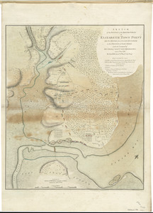
Sketch of the position of the British forces at Elizabeth Town Point after their return from Connecticut Farm, in the province...
42.
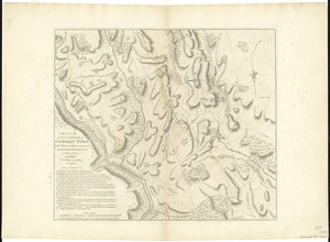
Sketch of the surprise of German Town by the American forces commanded by General Washington October 4th 1777
43.
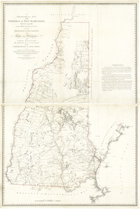
A topographical map of the Province of New Hampshire
44.
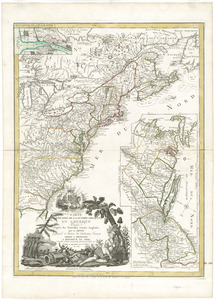
L'Amerique divisée en septentrionale et méridionale, subdivisée en ses principales parties, dressée sur les relations les...
45.
Amerique Septentrionale divisée en ses principales parties, ou sont distingués les vns des autres les estats suivant qu'il...
46.
L'Amerique Septentrionale, ou se remarquent les Etats Unis
47.
Carte des Etats-Unis d'Amérique, et du cours du Mississippi : rédigée d'après différentes cartes et relations Anglaises et...
48.
Carte generale des colonies angloises dans l'Amerique Septentrionale pour l'intelligence de la guerre presente : d'apres des...
49.
Chart of the Banks of Newfoundland, drawn from a great number of hydrographical surveys, these charts are followed, according...
50.
The coast of New Schotland, New England, the gulph and river of St. Laurence : the islands of New Foundland, Cape Breton, St....
51.
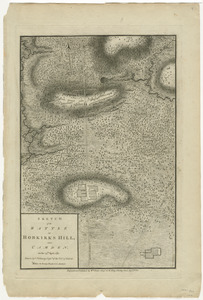
Sketch of the battle of Hobkirks Hill, near Camden, on the 25th April 1781
52.
The United States of America laid down from the best authorities, agreeable to the Peace of 1783
53.
The United States of America with the British possessions of Canada, Nova Scotia, & of Newfoundland, divided with the French :...
54.
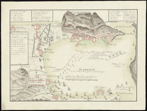
Abriss der stadt Gibraltar und der darinn befindlichen festen platze, nebst dem meerbusen von Algesiras
55.
Carte du theatre de la guerre presente en Amerique
56.
Carte generale des treize Etats Unis, de l'Amerique septentrionale = Kaart van de dertien Verénigde Staaten, in Noord Amerika
57.
Plan de Gibraltar
58.
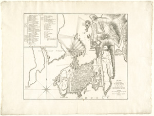
Plan de la position de l'armée française au tour de Newport dans Rhode Island et du mouillage de l'escadre dans la rade de...
59.
Plan de la ville et des forts de Gibraltar, avec la Baye d'Algesiras
60.
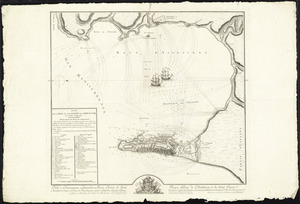
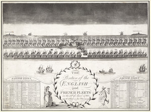
The position of the English and French fleets on the 12th of April 1782 at 10 oclock in the morning
‹ Prev
Next ›
1
2
3
4
5
6
7
…
16
17