A topographical map of the Province of New Hampshire
This map is also available in American Revolutionary Geographies Online (ARGO), a collections portal especially built for material relating to the American Revolutionary War Era. Visit ARGO to learn more about this item and explore the historical geography of North America in the late eighteenth century.
Item Information
- Title:
- A topographical map of the Province of New Hampshire
- Description:
-
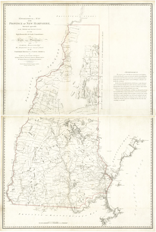
This rare map of New Hampshire was prepared from surveys by Samuel Holland - famed engineer who entered British service during the French and Indian War (1754-1763). The map depicts New Hampshire in great detail, illustrating rivers, streams, lakes, elevations, township boundaries, roads, and structures. Two great arcs delineate the boundary of a parcel known as "Mason's Curve." The parcel, owned by John Mason (1586-1635), was originally located between the Merrimack and Kennebeck Rivers, however in 1748 was sold by one of Mason's descendants to twelve investors from Portsmouth. It is believed these investors commissioned the surveys in 1768-69 to more accurately locate the boundary of the landholding.
- Creator:
- Holland, Samuel, 1728-1801
- Publisher:
- Faden, William, 1749-1836
- Name on Item:
-
surveyed agreeably to the orders and instructions of the Right Honourable the Lords Commissioners for Trade and Plantations; unto Samuel Holland, Esqr., His Majesty's Surveyor General of Lands for the Northern District of North America; by the following gentlemen his deputies: Mr. Thomas Wright ... [et al.].
- Date:
-
1784
- Format:
-
Maps/Atlases
- Location:
- George Washington's Mount Vernon
- Collection (local):
-
Richard H. Brown Revolutionary War Map Collection at Mount Vernon
- Subjects:
-
New Hampshire--Administrative and political divisions--Maps--Early works to 1800
- Places:
-
New Hampshire
- Extent:
- 1 map on 2 sheets : hand col. ; 119 x 78 cm.
- Terms of Use:
-
No known copyright restrictions.
This work is licensed for use under a Creative Commons Attribution Non-Commercial Share Alike License (CC BY-NC-SA).

- Publisher:
-
London :
Printed for William Faden
- Scale:
-
Scale [ca. 1:260,000]
- Language:
-
English
- Catalog Record:
-
MVLA record
- Notes:
-
Relief shown by hachures.
Shows township and patent boundaries.
Includes "Advertisement."
- Identifier:
-
06_01_008210


![[A map of part of Pennsylvania & Maryland intended to shew, at one view, the several places proposed for opening a communication between the waters of the Delaware & Chesopeak Bays]](https://bpldcassets.blob.core.windows.net/derivatives/images/commonwealth:z603vt12v/image_thumbnail_300.jpg)
