Toggle navigation
LMEC Home
Exhibitions
Georeferencing
Tools for Teachers
Collections
My Favorites
Sign Up / Log In
Search
Search the map portal
Map Collection
Map Collection
Map Sets
Search
Search
Search for
Search In
All Fields
Creator
Title
Subject
Place
Search All Digital Collections
Advanced Search
100 Results
My Search
Start Over
More Like
commonwealth:z603vr22p
Remove constraint More Like: commonwealth:z603vr22p
Filter your Search
Place
North and Central America
100
New York
99
United States
99
Manhattan
54
Fort Washington (historical)
9
Brooklyn (borough)
8
New Jersey
8
Bronx
5
more
Place
»
Topic
Manhattan (New York, N.Y.)--Maps
51
New York (N.Y.)--Maps
48
United States--History--Revolution, 1775-1783--Maps
19
Brooklyn (New York, N.Y.)--Maps
9
Fort Washington (New York, N.Y.)--Maps
8
Railroads--New York (State)--New York--Maps
8
New York Harbor (N.Y. and N.J.)--Maps
7
Real property--New York (State)--New York--Maps
7
more
Topic
»
Date
Date range begin
–
Date range end
Current results range from
1733
to
1939
View distribution
Creator
Kitchin, Thomas, 1719-1784
5
Dripps, M. (Matthew)
4
Hayward, George, approximately 1800-
4
Andrews, Peter, active 1765-1782
3
Martin, Reinhard Jacob
3
Rand McNally and Company
3
Ratzer, Bernard
3
Amherst, Jeffery Amherst, Baron, 1717-1797
2
more
Creator
»
Format
Maps/Atlases
100
Manuscripts
3
Georeferenced
Yes
12
No
88
Collection
Norman B. Leventhal Map & Education Center Collection
50
American Revolutionary War-Era Maps
46
Urban Maps
33
William L. Clements Library Collection
27
New York Public Library Collection
14
American Antiquarian Society Collection
4
New-York Historical Society Collection
4
Maritime Charts and Atlases
2
more
Collection
»
Available to use
No known restrictions
54
Creative Commons license
14
Search Constraints
Sort by relevance
relevance
title
date (asc)
date (desc)
Number of results to display per page
20 per page
10
per page
20
per page
50
per page
100
per page
View results as:
grid view
map view
Search Results
41.
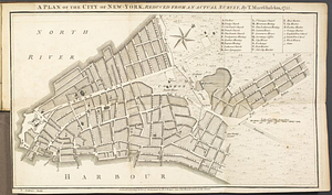
A Plan of the city of New York
42.
Plan of the city of New York : showing the made and swamp land
43.
Plan of the city of New York in North America : surveyed in the years 1766 & 1767
44.
A plan of the city of New-York, reduced from an actual survey
45.
The provinces of New York, and New Jersey, : with part of Pensilvania [sic], and the province of Quebec
46.
Rand McNally & Co.'s map of New York City, Brooklyn, Jersey City and vicinity
47.
The seat of action, between the British and American forces or an authentic plan of the western part of Long Island, with the...
48.
Sketch of the country illustrating the late engagement in Long Island
49.
The strangers mercantile guide map of the cities of New York, Brooklyn, Jersey City, Hoboken, etc
50.
This plan of the City of New York (within the palisades which were erected in the year 1743) was made for the purpose of...
51.
Various plans and draughts of cities, towns, harbours &c. drawn from the latest authorities
52.
Ville de Manathe ou Nouvelle-Yorc
53.
British troop dispositions in and near New York City, Sept. 2d 1781
54.
Center of New York, first city of the world
55.
The city of New York as laid out by the Commissioners with the surrounding country
56.
Ye commencement for draft of New York Island
57.
The Delancey lands on Manhattan Island
58.
Disposition of the British forces on Long Island, Staten Island, and Manhattan Island, under Cornwallis and Knyphausen
59.
Downtown district of Manhattan
60.
Ground plan of the markets of the City of New-York
‹ Prev
Next ›
1
2
3
4
5